Nicole to bring heavy rain, strong winds, and a marginal severe threat to Middle Georgia.
MACON, Georgia (41NBC/WMGT) – Tropical Storm Nicole will bring some hazardous conditions to Middle Georgia this evening and tonight.
Today


The clouds and wind that took over Middle Georgia yesterday will only continue to to affect the region today. This afternoon, however, we are adding Nicole’s rain to the mix. High temperatures will be in the mid to upper 60s all day today, not changing much at all through the afternoon or evening as the rainy weather sets in. Wind gusts throughout the afternoon and evening will likely push north of 40 mph at times from the northeast.


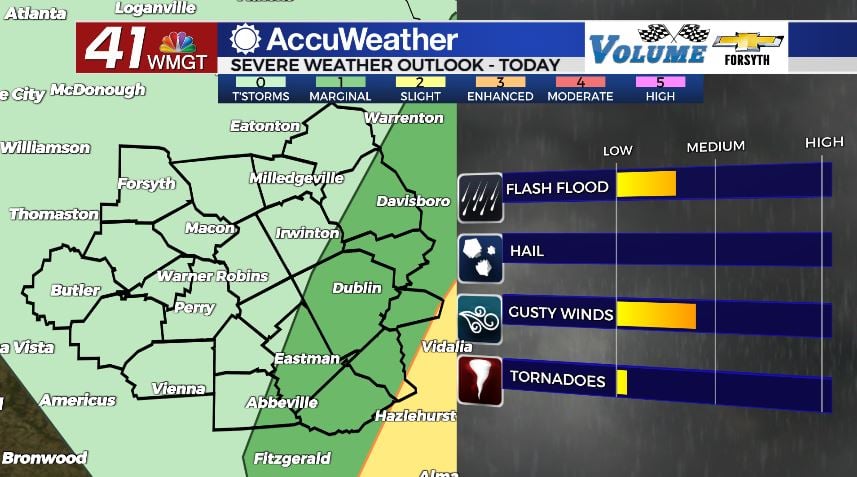
There is a small severe weather threat today in part of Middle Georgia: a Level 1 “Marginal” threat exists for the eastern third of Middle Georgia this afternoon and evening, and it’s mainly in regards to spin up tornado potential. The Storm Prediction Center (SPC) has issued a 2% chance for a tornado in that region for this afternoon and evening. So while the risk for a tornado is not high, it also is not zero. The primary threats associated with Nicole will be the powerful wind gusts and heavy downpours that are possible for everyone in Middle Georgia.


The heaviest rain will move in during the overnight hours tonight and into tomorrow morning. The strongest winds will also move in during the overnight hours tonight. The winds will shift from the northeast towards the southeast overnight as the heavy rain persists. Overnight low temperatures will be in the low to mid 60s, or just a few degrees cooler (or not at all) than the afternoon highs.
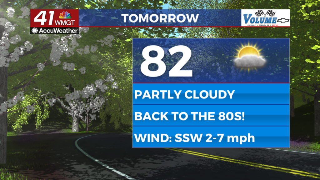
Tomorrow


We will continue to see heavy rain across Middle Georgia to begin our Friday. The winds will now blow from the southwest as we go through the day with gusts still reaching over 30 mph early. The winds will calm as Nicole quickly moves north during the afternoon, however. Rain activity will slow in Middle Georgia around lunchtime as temperatures peak in the upper 60s and lower 70s. All rain activity should cease ahead of High School football playoffs in the evening, however the clouds and some relatively strong breezes will likely persist.


Tomorrow night we will begin to see that wind shift more towards the west as many of the overhead clouds clear out. This will allow low temperatures to drop back into the mid 50s ahead of Saturday morning. Winds will not be nearly as strong with sustained speeds at 5-13 mph and gusts up to about 20 mph.
The Weekend

Saturday will see partly sunny skies with a few isolated chances for showers and storms, especially late. It will still be somewhat breezy as the westerly winds blow in at 6-14 mph. Gusts could still reach speeds of up to 20 mph. Afternoon highs will mainly reach the lower 7os around Middle Georgia. The cold front will move through during the evening, bringing a couple of storms, however no severe weather is expected. The wind will shift to the northwest ahead of Saturday night, allowing temperatures to plummet into the mid and upper 30s around Middle Georgia. Overnight skies should be mostly clear.
Sunday will be a mostly sunny day, however it will be a much cooler afternoon. Highs will only reach the upper 50s and lower 60s as north-northwest winds blow in at 5-10 mph. Gusts could reach upwards of 17 mph. No rain is expected Sunday with relatively clear conditions sticking around into the overnight. Lows will be in the low to mid 30s heading into Monday morning.

Follow Meteorologist Aaron Lowery on Facebook (Aaron Lowery 41NBC) and Twitter (@ALowWX) for weather updates throughout the day. Also, you can watch his forecasts Monday through Friday on 41NBC News at Daybreak (6-7 a.m.) and 41Today (11 a.m)