Nicer weather returns for the weekend
MACON, Georgia (41NBC/WMGT) – Sunny skies will return to Middle Georgia for the weekend following Friday’s wet weather.
The Rest of the Evening


Storms will work to clear out as we roll through the suppertime hours. Skies will begin to clear following that with temperatures dropping into the low to mid 30s by tomorrow morning. Even though storms themselves have not been very powerful, strong ambient winds from the southwest (10-25 mph G 30+) will remain in the area into tonight. A wind advisory is in effect until 1:00 am tonight/tomorrow morning to account for this.
Tomorrow


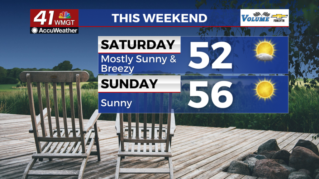
Mostly sunny skies with respectable breezes from the west-northwest are likely tomorrow. High temperatures will mainly be in the lower 50s, however with winds gusting over 20 mph at times tomorrow afternoon the chills could be in the upper 40s.


Overnight some cirrus clouds are likely to pass over, but they will bring no rain and also will do little for insulation. Luckily the winds will be calmer from the west-southwest around 5 mph as temperatures drop below freezing.
Sunday and Beyond


It will be sunnier and warmer Sunday with temperatures reaching into the mid to upper 50s. The wind will also be a lot calmer out of the west-northwest at about 5-10 mph. Gusts could push over 15 mph at times. Overnight will be partly cloudy, however, with temperatures again falling below freezing.

Next week looks to be a lot colder with some cold rain possible Monday and lows into the teens come Tuesday night. High temperatures by Wednesday could be in the upper 30s/lower 40s.

Follow Meteorologist Aaron Lowery on Facebook (Aaron Lowery 41NBC) and Twitter (@ALowWX) for weather updates throughout the day. Also, you can watch his forecasts Monday through Friday on 41NBC News at 4, 5, 5:30, 6, and 11 PM.