Mostly cloudy again Thursday
MACON, Georgia (41NBC/WMGT) –
.
This Evening


A cloudy morning has cleared out some this afternoon, however many of those clouds will return overnight and into tomorrow morning. Low temperatures should be similar to last night if not a couple of degrees cooler in the lower 50s. The wind will be light and variable and fog will be possible, especially early Thursday morning.
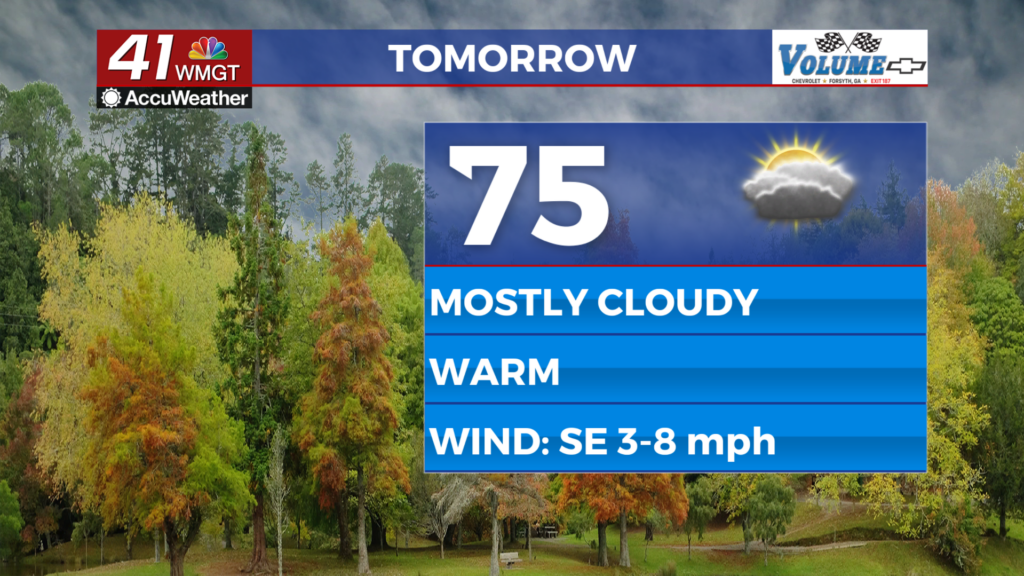
Tomorrow


Thursday will still be plenty warm but also mostly cloudy. Temperatures will likely top off a couple of degrees cooler than Wednesday afternoon in the low to mid 70s. Wind will flow from the southeast around 5 mph. A couple of spotty showers could be possible in the late evening hours.


Overnight will be partly cloudy with temperatures expected to only drop into the mid to upper 50s. The wind will flow from the southeast-southeast around 5 mph. A stray shower or two will be possible along with some fog.
Friday and Beyond


Attention Friday will be to the west in Mississippi and Alabama as a cold front will spawn several storms in the afternoon. The severe threat in that region remains a Level 2/5 at this time. That front will move through Georgia on Saturday. Friday should be partly cloudy and rather breezy and warm for Middle Georgia with a chance for a shower overnight. Once the cold front moves through Georgia expect powerful northwest winds on the backside to make things blustery on Sunday. This will ultimately lead to sub-freezing temperatures to start the new work week.

Follow Chief Meteorologist Aaron Lowery on Facebook (Aaron Lowery 41NBC) and X (@ALowWX) for weather updates throughout the day. Also, you can watch his forecasts Monday through Friday on 41NBC News at 4, 5, 5:30, 6, and 11 p.m.


