

Morning fog gives way to unseasonably warm temperatures
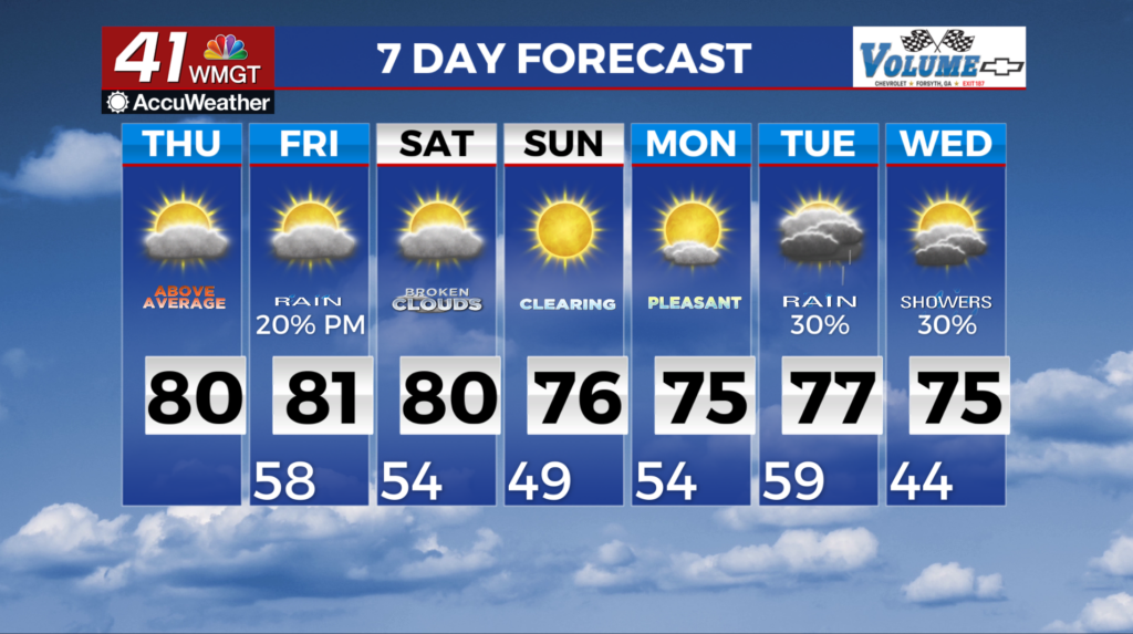
MACON, Georgia (41NBC/WMGT) – Split flow aloft is in place with two separate systems creating a complex moisture draw near the area. Deep trough out of the west that has subtropical 


 connections with a shortwave rotating through it emerges into Texas, with some weak cyclogenesis at the surface taking place will aid in drawing up some moisture to the west. To the north, the polar jet will have a sharp wave diving into the upper Midwest and through the Great Lakes that may begin to tap into moisture drawn up from the more southern system. The end result isn’t as impressive as the build up may sound; some rain showers may be possible Thursday evening into the overnight hours across northern Georgia, but the overall probabilities are low. Rainfall amounts should be light. It will remain unseasonably warm. Highs today will top out in the 70s and even some 80s, although areas of western Georgia may see lower numbers thanks to cloud cover lingering a bit longer than expected. More of the same for Friday, with highs in the 70s and 80s that represents a 10-15 degree departure from the average. The extended period starts off with weak ridging across the state keeping things dry but that will be short-lived. Weakening high pressure centered off the Eastern Seaboard keeps a warm frontal boundary north of the state through early Friday morning. This ridging will allow temps to reach into the upper 70s to the lower 80s across much of the area Friday. The next frontal system pushes into the lower to mid Mississippi River Valley with deeper moisture arriving in Northwest Georgia shortly after sunrise Friday. Warm moist southwest flow sets up ahead of this frontal boundary which will also help increase those daytime highs Friday. Looks like showers will begin to push into Northwest Georgia around midday slowly moving across the state through Saturday. Things clear out behind this front Sunday with increasing clouds again late Monday ahead of the second frontal boundary.

