More rain likely Friday as the cold front stalls out

MACON, Georgia (41NBC/WMGT) – The cold front has arrived in Middle Georgia and will linger over the state through Friday bringing more rain.
This Evening


Storms began in the mid afternoon in the western counties of Middle Georgia and will continue to push eastward through the evening and into tonight. While the severe threat has been contracted to only include the northeastern counties of the region a few strong wind gusts remain possible everywhere.


Overnight expect skies to stay cloudy as a few showers and storms linger. Lows will hover around 70 degrees for most of the region accompanied by light wind from the southwest. Fog is also expected through the overnight hours and into the sunrise Friday.
Tomorrow


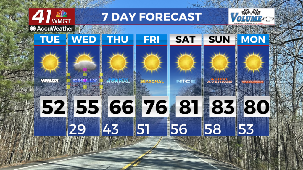
A cloudy day is expected Friday and temperatures will be much cooler as a result of the cold front that arrived Thursday. Highs will largely reach the lower 80s as the wind remains out of the southwest around 5 mph.


Another round of storms is expected starting during lunchtime and continuing through the evening. No areas have been highlighted for severe weather threats however the most organized of storms may again bring a few damaging gusts.


Overnight will stay cloudy with a few lingering showers. Lows will be in the mid to upper 60s as the wind becomes light and variable. Fog will still remain possible as well.
This Weekend


The weekend should overall be rather pleasant however Saturday may still have a decent amount of clouds left over. A few stray showers will also be possible Saturday afternoon as highs reach into the low to mid 80s. Sunday will be nicer as partly sunny conditions return accompanied by pleasant breezes from the northeast. Highs will return to the mid 80s by this point as well.
The Tropics


Tropical Storm Humberto continues to churn in the Atlantic Basin and not far too its west Invest94L is doing the same. Invest94L will likely develop into Tropical Storm Imelda within the next 48 hours as the odds for that are up to 80% with 90% odds over the next 7 days. Model guidance for this system is all over the place however impacts to the Southeastern US look very possible. It will be important to monitor updates as they come as it could drastically change the local forecast next week.

Follow Chief Meteorologist Aaron Lowery on Facebook (Aaron Lowery 41NBC) and X (@ALowWX) for weather updates throughout the day. Also, you can watch his forecasts Monday through Friday on 41NBC News at 4, 5, 5:30, 6, and 11 p.m.