More rain leads to cooler temps for the weekend
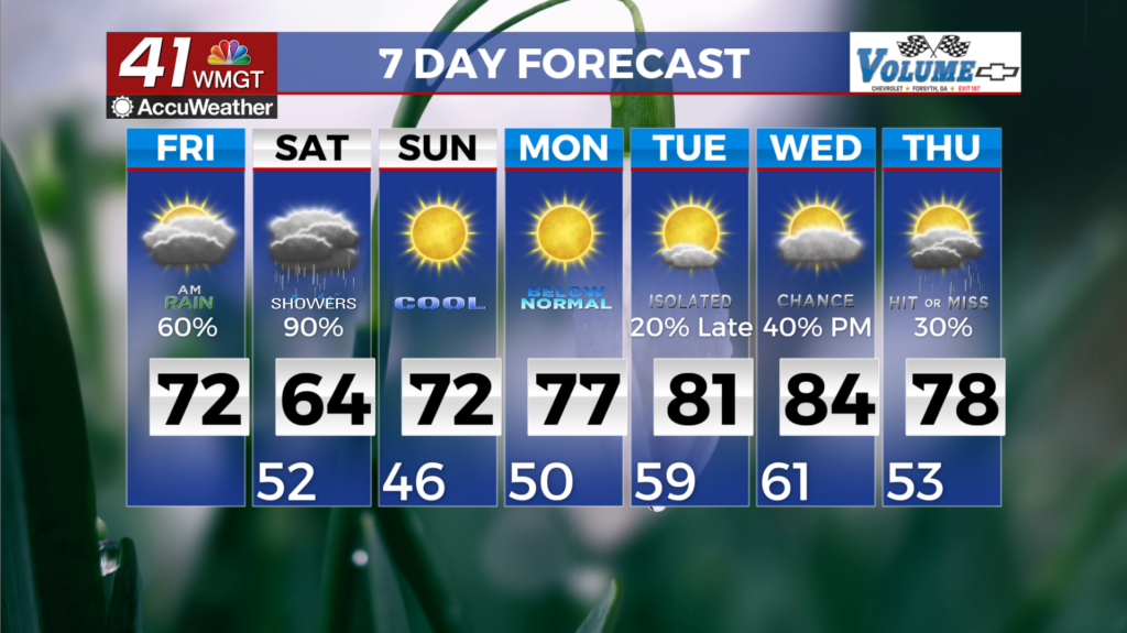
MACON, Georgia (41NBC/WMGT) – A weak disturbance will travel zonally, which will promote scattered showers in Middle Georgia Friday morning as it overruns a lingering front. Another 


trough extends from the closed low towards Central Texas by Friday morning. As this trough deepens and swings eastward over the course of the day, the midlevel flow begins to shift to southwesterly and the surface low begins to develop over the North-Central Gulf, leading to moisture return over the region. Showers and thunderstorms will increase this afternoon. Lingering 


cooler air at the surface and overcast skies will keep high temperatures limited to the upper 60s to low 70s on Friday afternoon. Widespread rain is forecast by Friday night into Saturday as the trough approaches and the developing low moves northeastward through the area. Rain chances begins to taper off during the afternoon hours, coming to an end on Saturday night. High 


pressure establishes on Sunday and kicks off another dry period with building heat. Modest temperatures on Sunday in the upper 60s and low 70s will quickly rebound on Monday as they climb back into the upper 70s and 80s for the remainder of the week. This will be accompanied by drier conditions, with relative humidity falling into the 30 percent range during the afternoon. Overnight low Sunday into Monday will be in the low 40s with some upper 30s possible across higher elevations. Lows will rebound with the highs, and by the end of the week, they’ll climb back into the mid to upper 50s.