
More heat; a few storms for Middle Georgia Monday afternoon.
MACON, Georgia (41NBC/WMGT) – Hot conditions carry into the new week from the weekend, and a stalled out front will initiate some isolated storms.
Today
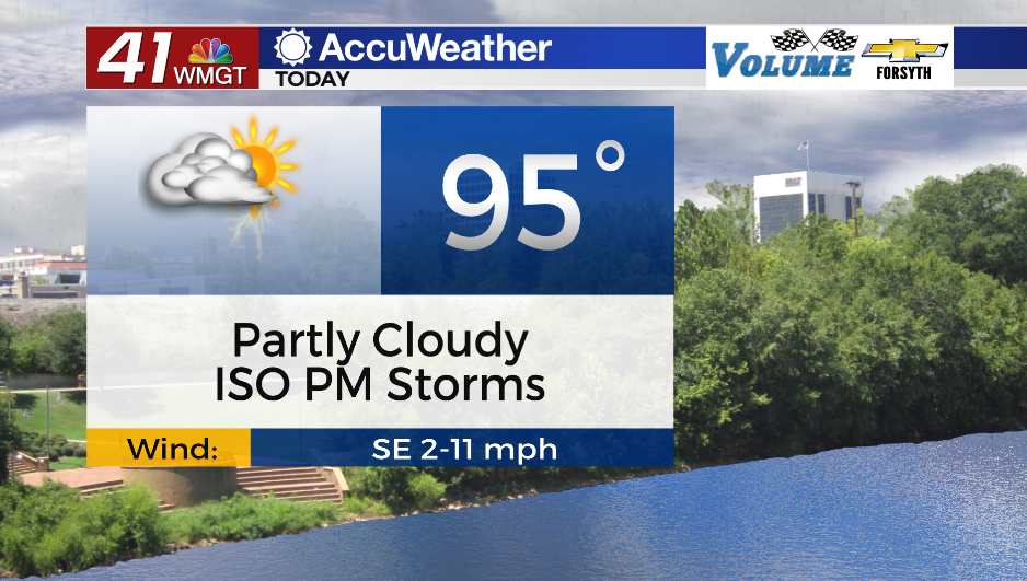
A cold front made its way into the northern third of Georgia yesterday and into this morning. This front is being stalled over the region to begin the new week thanks to Hurricane Franklin off the east coast and the newly developed Idalia to the south. This will lead to some isolated to scattered storms around much of Georgia later this afternoon. Middle Georgia will see a few of these following temperatures climbing into the low to mid 90s. Partly to mostly cloudy skies will be likely during the afternoon around the region. A Level 1 “Marginal” threat is in place for the northwestern half of the region. Anywhere in the region can see storms today, however. A few strong wind gusts are the primary severe concern.


Tonight a few storms will linger early while daytime heat remains in play. Most storms should fade out by midnight or shortly thereafter. Skies will be partly to mostly cloudy with low temperatures in the low to mid 70s. Ambient winds will blow from the southeast at around 5 mph.
Tuesday and Beyond
Tuesday will be a bit cooler than Monday with added cloud cover and further increased storm odds in the afternoon. Highs should only reach the upper 80s and lower 90s with winds largely remaining out of the southeast. Storms will likely continue into the overnight hours with the winds shifting more towards the northeast as Idalia approaches the bend from the Florida Panhandle to the Peninsula. More widespread rain will be likely heading into Wednesday morning as Idalia nears/makes landfall. Overnight lows will drop into the low 70s.


Much of Idalia’s effects will more than likely remain to the southeast of Middle Georgia on Wednesday, however some strong winds 30-40 mph and heavy rain will still be possible in the southeastern counties of our region. Those further northwest could see a low threat for brief spin-up tornadoes. Flash flooding will be a concern around the region thanks to the rain from Monday and Tuesday, however the southeastern counties will see the highest risk in that regard.
Sunny conditions will follow Idalia’s passing come Thursday.

Follow Meteorologist Aaron Lowery on Facebook (Aaron Lowery 41NBC) and Twitter (@ALowWX) for weather updates throughout the day. Also, you can watch his forecasts Monday through Friday on 41NBC News at Daybreak (5-7 a.m.) and 41Today (11 a.m).