More cloud cover rolls in Thursday
MACON, Georgia (41NBC/WMGT) – Cloud cover will begin to ramp up Thursday ahead of the next weathermaker.
This Evening


It’s been a sunny afternoon around Middle Georgia and skies will stay clear through tonight. Conditions should be colder than last night with lows dropping back into the mid 20s for much of the region. Expect light wind from the northwest. Middle Georgians would be wise to drip their faucets once again.
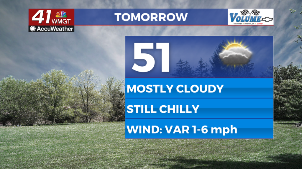
Tomorrow


There should be a healthy dose of sunshine early before clouds begin to take over in the late morning hours. It will largely be upper level clouds so some sun should get through for most of the day. Expect high temperatures in the low to mid 50s once again as the wind becomes light and variable thanks to high pressure in the area.


Overnight will be partly to mostly cloudy with lows expected below freezing again. We may be just above faucet dripping territory, however. Wind will remain light and variable.
Friday and Beyond


Mostly cloudy skies are expected again Friday with temperatures refusing to climb above the low to mid 50s. The wind will remain light and variable until a shift to the north-northwest happens overnight Friday into Saturday. Some cold rain showers will be possible overnight with a shift into snow likely heading into Saturday. The odds for snow are highest in the northeastern counties of the region, however at this time accumulations in the heaviest spots are forecast to remain under 2 inches. One way or another all weekend long will be rather windy across all of Middle Georgia.

Follow Chief Meteorologist Aaron Lowery on Facebook (Aaron Lowery 41NBC) and X (@ALowWX) for weather updates throughout the day. Also, you can watch his forecasts Monday through Friday on 41NBC News at 4, 5, 5:30, 6, and 11 p.m.

