Middle Georgia could see strong to severe storms Wednesday afternoon and evening
MACON, Georgia (41NBC/WMGT) – A weak cold front will bring some thunderstorms to Middle Georgia this afternoon, some of which could be severe.
Today


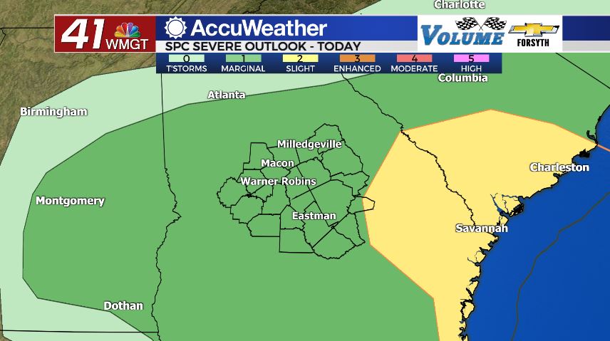
A few rounds of heavy rain made their way through Middle Georgia during the overnight and early morning hours Wednesday. It’s a bit of relief for those who have been suffering from the rapidly increasing pollen levels. But now the attention will turn to later this afternoon when a round or two of severe storms will be possible. As of now the majority of Middle Georgia is under a Level 1 “Marginal” risk. The last of the morning rain should move out of the region by 1:00 the latest, allowing a bit of clearing leading into the afternoon hours. A few pockets of sunshine are likely, especially in the southern counties of the region. They will see highs in the mid 70s while the northern counties see highs in the lower 70s.


Provided there isn’t too much sun later this afternoon to accompany those 70s, the overall risk for severe weather should remain low. The system is overall weak and disorganized, taking away from potential storm dynamic. A sunny afternoon ahead of the stormy weather heading into the evening could potentially cancel that out and increase the risk, however at this time it looks like a decent amount of cloud cover will hang around. The primary risks later today will be heavy rain and strong wind gusts, but a spin-up tornado or some small hail cannot be ruled out. The threat should end not too long after sunset, and the highest risk zone in Georgia is a Level 2 “Slight” risk off to the east. It does include the eastern tip of Treutlen County.


Once the rain stops, cloud cover will begin to part heading towards tomorrow morning. Humidity levels are expected to remain high, so some fog will be likely rolling into tomorrow morning as lows drop into the upper 40s and lower 50s. There should be some pretty sunrises in the morning, however, as a small handful of clouds should still be hanging around.
Tomorrow


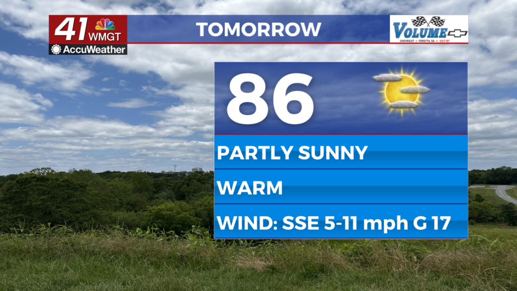
The forecast for St. Patrick’s Day continues to improve as it falls between the passing of two storm systems. There will likely be a few clouds here and there during the afternoon hours, but the sun will be a welcome presence for most of the day. Highs will reach the low to mid 70s around the region once again as the wind generally blows in from the west at around 5 mph. Rain is not expected tomorrow, so any outdoor festivities (such as the St. Patrick’s Day Parade) should all be good to go.

Cloud cover will begin to return during the late overnight and early morning hours of Friday. A full moon is on deck for tomorrow night as well: the Full Worm Moon, named for all of the earthworms that begin to thaw around this time of year. Low temperatures will remain on the mild side as we again only drop into the upper 40s and lower 50s thanks to lingering humidity. Cloud cover will nearly be a blanket by the time the sunrise arrives on Friday.
Friday and the Weekend


The morning will begin with plenty of cloud cover as the next cold front approaches from the west. There unfortunately is already a severe weather risk associated with this front, and as of now it is a Level 1 “Marginal” risk for all of the region. The rain looks to move in just ahead of lunchtime, so hopefully cloudy conditions and cooler temperatures will keep the threat down. Also to note: models are already hinting at the cold front weakening as it enters the region. We have seen that happen several times between the fall of 2021 and now, and the past few times it has happened the severe threat didn’t pan out. Hopefully that pattern continues.

Saturday will see mostly sunny conditions as highs stay in the lower 70s. Wind will be westerly at 10-15 mph.
Sunday will also see sunny conditions as highs stay in the lower 70s. Wind will be northwesterly at 5-10 mph.

Follow Meteorologist Aaron Lowery on Facebook (Aaron Lowery 41NBC) and Twitter (@ALowWX) for weather updates throughout the day. Also, you can watch his forecasts Monday through Friday on 41NBC News at Daybreak (6-7 a.m.) and 41Today (11 a.m).


