Local contractor to begin $1.9M roadwork in Macon-Bibb’s Paving the Way program
Between 2020 and now, the county says 45.539 miles of road have been repaved.
UPDATE (8/26/25): Macon-Bibb County has announced the second package of roads to be paved as part of the 36.18 miles put out for bid in July.
The county says work should begin within a few weeks and that more roads could be added “once the final costs are determined.”
Check out the list below:
| Road | From-To | Length (miles) |
|---|---|---|
| Maplewood Dr. | S. Stratford Oaks Dr. – N. Stratford Oaks Dr. | 0.06 |
| Maplewood Dr. | S. Beechwood Dr. – Leo Place | 0.06 |
| Maplewood Dr. | S. Beechwood Dr. – N. Stratford Oaks Dr. | 0.07 |
| N. Stratford Oaks Dr. | Maplewood Dr. – S. Stratford Oaks Dr. | 0.12 |
| Rivoli Oaks Circle | Rivoli Oaks Dr. – Rivoli Oaks Dr. | 0.26 |
| S. Stratford Oaks Dr. | N. Stratford Oaks Dr. – Maplewood Dr. | 0.12 |
| Madison | Madison North Dr. – Madison South Dr. | 0.02 |
| Madison | Madison South Dr. – Madison North Dr. | 0.03 |
| 1st Street | Liberty St. – North Dead End | 0.01 |
| 1st Street | Liberty St. – Bright St. | 0.04 |
| Hydrolia St. | Church St. – Main St. | 0.04 |
| Main St. | Main St. – Hydrolia St. | 0.03 |
| Main St. | Clinton St. – Schell Ave. | 0.05 |
| Main St. | Hydrolia St. – Garden St. | 0.05 |
| Main St. | Hydrolia St. – Schell Ave. | 0.04 |
| South Avondale Circle | Hamlin Dr. – Home Ave. | 0.16 |
| South Avondale Circle | Hawkinsville Rd. – Driveway | 0.08 |
| South Avondale Circle | Driveway – Driveway | 0.05 |
| South Avondale Circle | Driveway – Hamlin Dr. | 0.04 |
| High Oak Dr. | Shirley Court – Cul-De-Sac | 0.19 |
| Pine Valley Dr. | West Oak Dr. – No Name Road | 0.25 |
| Plantation Way | Peake Rd. N. – Plant. Centre Dr. N. | 0.32 |
| Lamar Rd. | Chambliss Dr. – Colaparchee Rd. | 0.48 |
| Old Forsyth Rd. | Forsyth Rd. – LaGrange Place | 0.25 |
| Peake Rd. | Tucker Rd. – I-475 Bridge | 1.14 |
| West Hickory Ct. | Two Oak Dr. – Cul-De-Sac | 0.07 |
| Elpis St. | Lilly Ave. – Pansy Ave. | 0.09 |
| Iris St. | Poppy Ave. – Blossom Ave. | 0.04 |
| Zinnia St. | Pansy Ave. – East Dead End | 0.18 |
| Straight St. | Key St. – Woodard Ave. | 0.09 |
| May Ave. | Zinnia St. – Bluebell St. | 0.05 |
| Blossom Ave. | Blue Bell St. – Zinnia St. | 0.04 |
| Blossom Ave. | Daffodil St. – 226 Feet North | 0.04 |
| Pansy Ave. | Zinnia St. – Crocus St. | 0.05 |
| Columbus Road | College Crossing Dr. – I-475 Bridge | 0.58 |
| Columbus Road | I-475 Bridge – Robinson Dr. | 0.92 |
| Old Skipper Road | Skipper Rd. – Dead End Fence | 0.30 |
| Ridge Court | Timber Ridge Dr. – West Cul-De-Sac | 0.10 |
| Timber Ridge Dr. | Hartley Bridge Rd. – White Pine Ct. | 0.20 |
| Timber Ridge Dr. | White Pine Ct. – Ridge Ct. | 0.08 |
| Timber Ridge Dr. | Ridge Ct. – Forest Pine Ct. | 0.09 |
| Timber Ridge Dr. | Forest Pine Ct. – Old Oak Rd. | 0.09 |
| Stewarts Lane | College St. – Madison St. | 0.10 |
| Williams Lane | College St. – Madison St. Lane | 0.05 |
| Williams Lane | Madison St. – Dr. Betty Tolbert Way | 0.05 |
| Brinwood Dr. | Greenbriar Rd. – Greenbriar Rd. East | 0.20 |
| Meadowbrook Dr. | Vallie Dr. – Meadowbrook Dr. | 0.04 |
| Nisbet Drive | Chambers Rd. – Reynolds Dr. | 1.35 |
| Thomas Place | Fairburn Ave. – Napier Ave. | 0.16 |
ORIGINAL STORY (8/19/25):
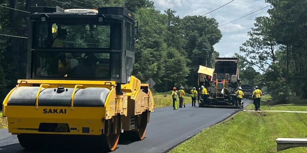
MACON, Georgia (41NBC/WMGT) – Macon-Bibb County Commissioners on Tuesday unanimously approved hiring an independent contractor to handle the next phase of the county’s Paving the Way program, according to a county news release.
According to Macon-Bibb County, Professional Paving Services, LLC, a local business, submitted the lowest bid of $1,896,165 out of eight contractors. The contract will be paid with Local Maintenance & Improvement Grant (LMIG) funds and the 2018 Special Purpose Local Option Sales Tax (SPLOST).
“We are moving forward even faster with our Paving the Way program, and I expect to see major improvements on these roads beginning in in the next few weeks,” Mayor Lester Miller said. “The condition of our roads is one of our community’s top priorities, and we are putting more money toward it than ever before.”
The first projects cover nearly nine miles of roadway and are expected to begin within 10 days, the release said. County officials say the work is part of the 36.18 miles of resurfacing projects put out for bid in July, with additional sections to be added later once final costs are determined.
Roads for this round were selected through a Roadbotics study of 1,100 miles of county-owned roads that ranked them on a scale of 1 to 5, with 5 being the worst. With the completion of this phase, nearly all roads rated 3 and higher will have been addressed, the release said.
Earlier this year, StreetScan rescanned all county roads, ranking them on a scale of 1 to 100. Officials said that study identified 459 roads totaling almost 130 miles and $44 million in costs for future paving.
“We identified the worst roads in our community and are focusing first on them, as well as roads that are heavily traveled every day,” Miller said. “There isn’t a part of our county that won’t have major improvements for daily travel.”
The first round of Paving the Way earlier this year allocated nearly $15 million from the General Fund, LMIG and SPLOST. Between 2020 and now, the county has repaved 45.539 miles of road, according to the release.
Work in this phase includes Chadwick Court, Bay Street, Riggins Mill Road, Churchill Street, Hillcrest Avenue, Sharon Drive, Fulton Mill Road and dozens of other neighborhood and connector streets across the county.
Here’s the full list:
| Road | From-To | Length (miles) |
|---|---|---|
| Chadwick Court | Chadwick – Cul-De-Sac | 0.09 |
| Chadwick Trail | Bowman Road – Chadwick Drive | 0.15 |
| Conway Drive | Senora Place – East Dead End | 0.04 |
| Conway Drive | Senora Place – Wera Place | 0.04 |
| Eastwick Court | Chadwick Drive – Cul-De-Sac | 0.07 |
| Eastwick Place | Chadwick Drive – Cul-De-Sac | 0.11 |
| Glen Hill Court | Forest Hill Road – Cul-De-Sac | 0.08 |
| North Haven Drive | Primrose Walk – North Haven Way | 0.04 |
| N. Pine Knoll Court | N. Pine Knoll Drive – Cul-De-Sac | 0.04 |
| Tiffin Court | Tiffin Circle – Cul-De-Sac | 0.04 |
| Bay Street | 7th Street – 6th Street | 0.15 |
| Cason Street | Spikes Street – South Dead End | 0.04 |
| Chappell Street | Cynthia Avenue – Broadway | 0.07 |
| Cherry Street | 3rd St. Outbound – 3rd St. Inbound | 0.02 |
| Giles Street | 3rd Street – 3rd Street | 0.02 |
| Melvin Place | Trammell Avenue – Roy Avenue | 0.08 |
| Melvin Place | Roy Avenue – Dorothy Avenue | 0.08 |
| Melvin Place | Dorothy Avenue – San Carlos Drive | 0.08 |
| Sheraton Drive | Inwood Drive – End Of R/W Pavement | 0.29 |
| Toombs Street | Holloway Street – North Dead End | 0.02 |
| Turpin Street | 9th Street – Railroad Signs | 0.05 |
| Creekwood Drive | Meriwood Drive – North End of R/W | 0.02 |
| Meriwood Drive | East R/W end to West R/W End | 0.15 |
| Queens Drive | Masseyville Road – Kings Park Circle | 0.11 |
| Riggins Mill Rd. | Augusta Avenue – RYDC Driveway | 0.06 |
| Riggins Mill Rd. | Brunswick Avenue – Augusta Avenue | 0.09 |
| Riggins Mill Rd. | RYDC D/W–Herbert Smart Airport Rd | 0.12 |
| Riggins Mill Rd. | Brunswick Avenue – Cordele Avenue | 0.10 |
| Austin Avenue | Austin Place – Mary Drive | 0.16 |
| Churchill Street | Ernest Street – Bankston Avenue | 0.04 |
| Churchill Street | Bankston Avenue – Buena Vista Drive | 0.06 |
| Churchill Street | Helon Street – Ernest Street | 0.04 |
| Churchill Street | Brentwood Avenue – Buenavista Drive | 0.13 |
| Churchill Street | Helon Street – Bailey Avenue | 0.08 |
| Churchill Street | Bailey Avenue – Willow Lane | 0.08 |
| Florence Avenue | St. Claire Street – Atherton Street | 0.07 |
| Gledhill Street | Bailey Avenue – Berkner Avenue | 0.20 |
| Greenview Ave. | Hillcrest Avenue – End of Paved R/W | 0.04 |
| Hillcrest Avenue | Ernest St. – Hillcrest Ind. Blvd. | 0.04 |
| Hillcrest Avenue | Napier Avenue – McKenzie Drive | 0.04 |
| Hillcrest Avenue | Hillcrest Blvd. – Mary Drive | 0.21 |
| Hillcrest Avenue | Hillcrest Road – Carroll Avenue | 0.32 |
| Sharon Drive | Hallwood Circle – Mimosa Drive | 0.04 |
| Sharon Drive | Mimosa Drive – Burton Avenue | 0.07 |
| Sharon Drive | Hallwood Circle – Hallwood Circle | 0.14 |
| Sharon Drive | Hallwood Circle – Edna Place Road | 0.06 |
| Sharon Drive | Macon Avenue – Radio Drive | 0.08 |
| Sharon Drive | Radio Drive – Bailey Avenue | 0.26 |
| Shaw Drive | Mary Drive – Austin Avenue | 0.17 |
| Winifred Way | Burton Avenue – Berkner Avenue | 0.24 |
| Bobby Court | Cul – De – Sac to Cul – De -Sac | 0.12 |
| Bobby Drive | Hartley Bridge Road – Bobby Court | 0.07 |
| David Coley Road | Lindy Coley Road – West Dead End | 0.04 |
| Elkan Avenue | Greenleaf Drive – Hillside Drive | 0.06 |
| Liberty Church Rd. | Vinson Road – White Pine Drive | 0.18 |
| Lindy Coley Road | David Coley Road – North Dead End | 0.04 |
| Mikado Avenue | Putnam Street – Toombs Street | 0.18 |
| Putnam Street | Houston Avenue – Mikado Avenue | 0.28 |
| Rhonda Drive | Nowell Drive – Regina Drive | 0.09 |
| Thomas Street | Houston Avenue – Broadway | 0.31 |
| Berkshire Drive | Winston Drive – North Dead-End Gate | 0.03 |
| India Avenue | Ballard Drive – Ballard Drive | 0.02 |
| India Avenue | Ballard Drive – Ballard Place | 0.06 |
| Maple Street | Jessamine Street – Violet Street | 0.04 |
| Pine Avenue | Violet Street – Rose Street | 0.05 |
| Pine Avenue | Rose Street – School D/W (72 Ft. N) | 0.01 |
| Violet Street | Pine Avenue – Walnut Avenue | 0.05 |
| Winston Drive | Westbury Drive – Greenwich Place | 0.16 |
| Winston Drive | Berkshire Drive – Westbury Drive | 0.05 |
| Winston Drive | Greenwich Place – Berkshire Drive | 0.16 |
| Gadson Drive | John Kennedy Dr. – John Kennedy Dr. | 0.06 |
| Gadson Drive | John Kennedy Dr. – Vinson Robeson Dr. | 0.11 |
| Fulton Mill Rd. | Skyhawk Circle – Hartley Bridge Rd. | 1.91 |