Last day of warmer conditions ahead of the next system
MACON, Georgia. (41NBC/WMGT) – Temperatures around Middle GA will begin to drop come Wednesday.
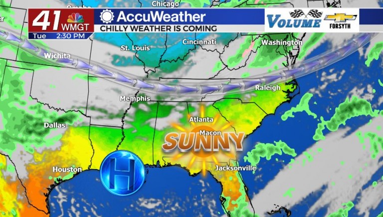
Today


The sunniest day of the week has arrived thanks to wind shifting back to the northwest during the early daylight hours. Dry air in the region will keep cloud cover to a minimum as temperatures this afternoon reach their peak of the week in the lower to mid 70s. The high pressure system will move southeast overnight and into tomorrow, slowly leaving the area ahead of the next potential system. The Middle GA skies will remain clear through the overnight hours tonight, however, as wind will persist from the north-northwest. Low temperatures heading into Wednesday morning will be in the upper 40s and lower 50s across the region.
Tomorrow


Wednesday will still be a nice day for the region with a good amount of sunshine likely early on. Cloud cover will begin to fill in from the north during the afternoon hours, primarily high level cirrus clouds. The wind will shift to the east, coming out of the northeast at about 5-10 mph. This wind will stick with us the next few days, persisting from the northeast at about that same speed. High temperatures Wednesday are not chilly by any means, but they will begin a downward trend, topping off in the upper 60s and low 70s across the region. Rain chances will also begin to climb overnight, though the only rain Middle GA will likely see before Thursday will be a stray shower or two. Our low temperatures heading into Thursday will warm once again, this time falling into the lower 50s for the majority of the region. Cloud cover will increase drastically Wednesday night into Thursday morning as well.
Thursday and Beyond


Like many of our fall weeks so far, our rain chance for the week is coming in just ahead of the weekend. Overall the impacts of this next system are expected to be low; the low pressure will likely not make it east of Mississippi as it pushes southeastward into the Gulf of Mexico. That being said, showers are still likely for much of Georgia Thursday afternoon into Friday with the system in the area. High temperatures will continue to fall, with low 60s and upper 50s expected both Thursday and Friday afternoon. Thursday will also see the most clouds this week, with thick clouds moving into the area ahead of Thursday morning and hanging overhead into Friday morning. At this time overall rain totals with this next system are expected to remain below an inch around the region.

Friday afternoon will see the cloud cover break throughout the day with temperatures again topping off in upper 50s for most of Middle GA. A few locations may still crack into the lower 60s. Shower activity will remain possible early Friday before sunshine returns during the evening. Once the sunny conditions return they will remain over Middle GA until at least early next week. Temperatures over the weekend will top off in the lower 60s as a gradual warming once again begins. This weekend is also the final weekend of Daylight Savings Time: don’t forget to set your clocks back an hour ahead of Sunday. Once the clocks are set back, our sunrises and sunsets will both occur an hour earlier.


Follow Meteorologist Aaron Lowery on Facebook (Aaron Lowery 41NBC) and Twitter (@ALowWX) for weather updates throughout the day. Also, you can watch his forecasts Monday through Friday on 41NBC News at Daybreak (6-7 a.m.) and 41Today (11 a.m).


Leave a Reply