


Humidity returns as rain chances climb this week
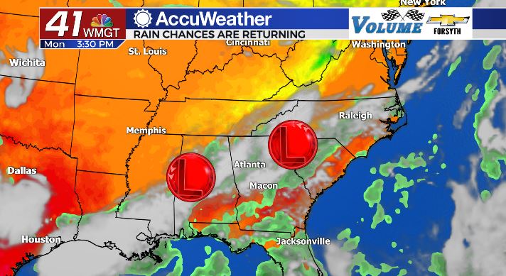
MACON, Georgia. (41NBC/WMGT)- Rain chances are on the rise for the first full week of September.
Today
It was a very pleasant weekend in Middle Georgia where sunshine dominated and humidity was low. Low temperatures overnight were in the low 60s and upper 50s, allowing some folks to save money on AC and open the windows to keep things cool. Entering into the new week, however, humidity has already begun to rise. Sunshine has begun the day in Middle Georgia, but plenty of cloud cover is on the way. Low pressure is entering the southeastern US along with some weak cold fronts, allowing for storm development. High temperatures this afternoon will primarily be in the lower 90s, however heat indices will be in the mid to upper 90s as more moisture returns to the atmosphere. Rain chances are higher for this afternoon as well, with about 30% of Middle Georgia likely to see an isolated shower or storm. For tonight, some of the cloud cover from this afternoon to remain while any PM storms dissipate. Temperatures will drop overnight into the lower 70s and upper 60s.
Tomorrow

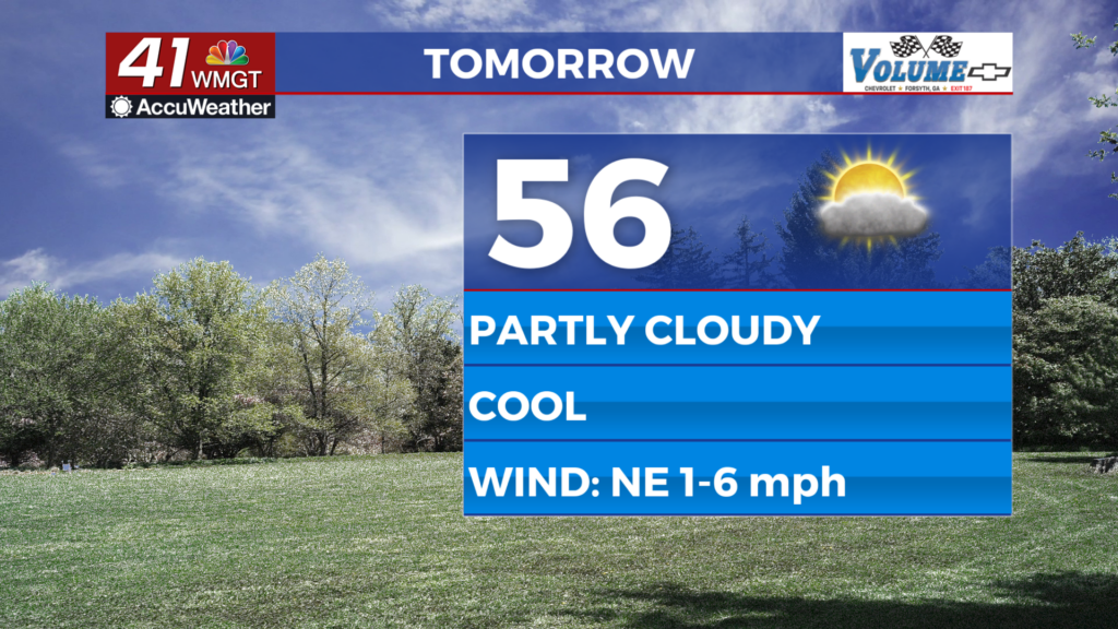
Unlike today, tomorrow will not begin on an all sunny note. Sure, most of us will likely see the sunrise to some degree. But cloud cover will be abundant once lunchtime hits, and storm chances are most certainly going to be higher. High temperatures for tomorrow afternoon may actually be a degree or two cooler around Middle Georgia, primarily due to the abundance of cloud cover expected. Unlike today, the storms tomorrow are not expected to be isolated, but rather scattered. Approximately half of the Middle GA region will see a shower or storm during the afternoon or evening tomorrow. Some locations could even see two. For tomorrow night, most of the clouds from the afternoon will remain overhead, and a few showers will be possible early. Low temperatures will once again be in the lower 70s and upper 60s.
Wednesday and the Back Half of the Week
Rain chances will climb even higher on Wednesday as one low pressure system moves through Georgia. Storms are expected to be widespread through the Middle Georgia region. Cloud cover will also be abundant; only a few pockets of sunshine are expected Wednesday afternoon. Temperatures will still climb into the upper 80s and lower 90s around the region. Storms will likely move in during the lunchtime hours and become more widespread during the dinnertime hours. Outdoor plans will not be favored as most if not all of the region will see thunderstorms. Keeping a rain jacket or umbrella in the car throughout this week is a good idea.
Rain chances will continue Thursday as temperatures drop slightly. As of now however Thursday does not have as high of a chance for rain as Wednesday. Widespread PM storms still remain likely however as the low pressure remains in the southeastern US over Georgia and South Carolina. The rainy trend should back off a bit on Friday as the low pressures clear out, and as of now the upcoming weekend looks similar to the one we just had for Labor Day.

Follow Meteorologist Aaron Lowery on Facebook (Aaron Lowery 41NBC) and Twitter (@ALowWX) for weather updates throughout the day. Also, you can watch his forecasts Monday through Friday on 41NBC News at Daybreak (6-7 a.m.) and 41Today (11 a.m).


Leave a Reply