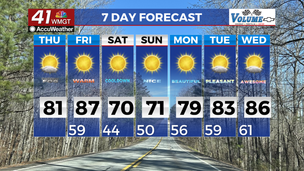
Hot week on deck for Middle Georgia
MACON, Georgia (41NBC/WMGT) – Summer conditions are taking over in Middle Georgia this week.
Today


It was another mild morning around Middle Georgia. Temperatures were in the low to mid 60s and there were a handful of clouds overhead. Partly cloudy skies will dominate Middle Georgia all week along along with winds out of the southwest and temperatures in the upper 80s and lower 90s. For today highs are likely to reach into the upper 80s for most of the region with a few select spots reaching into the lower 90s. A few isolated pop-up showers and storms will likely begin to fire up during the later afternoon hours. Most of the region will not see rain, however for those that do the storms should be short lived. Severe activity is not anticipated with any pop-up storms.


Partly cloudy conditions will roll into tonight for the region as well. The wind will remain out of the southwest at about 5 mph. A few showers will remain possible early on, however by midnight all rain activity should cease. Low temperatures will be in the low to mid 60s once again.
Tomorrow


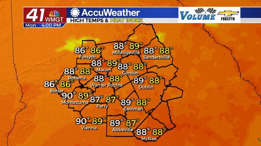
With the exception of slightly hotter temperatures in the afternoon, there is very little difference in the forecast between Monday and Tuesday. Cloud cover will be partly sunny as the wind continues to come in from the southwest, this time around 5-10 mph. Highs will reach into the lower 90s for more spots during the afternoon hours, and isolated showers and storms will fire up again during the later afternoon hours. No severe weather is expected.


Overnight the skies will still be partly cloudy as rain activity comes to a stop after the sunset. The southwest winds will continue to blow in at 5-10 mph, and lows will drop into the low to mid 60s.
Wednesday and Beyond

Almost the entirety of Middle Georgia should push into the 90s by Wednesday afternoon. Pop-up storms will fire up in the late afternoon hours under partly cloudy skies, and the wind will still come in from the south-southwest. Skies will remain partly cloudy overnight with lows in the mid to upper 60s.

Thursday will be the hottest day of the week as some spots come close to pushing into the mid 90s, likely setting record highs. Isolated storms will fire up in the afternoon and evening. Lows will be in the upper 60s and lower 70s under mostly cloudy skies.
A cold front on Friday will bring some more widespread rain chances as well as some cooler conditions, dropping temperatures in the region back into the low to mid 80s for afternoon highs. It will also shift the wind back to the northwest to dry things out a little from the humidity.

Follow Meteorologist Aaron Lowery on Facebook (Aaron Lowery 41NBC) and Twitter (@ALowWX) for weather updates throughout the day. Also, you can watch his forecasts Monday through Friday on 41NBC News at Daybreak (6-7 a.m.) and 41Today (11 a.m).