Heat and increased chances for storms kick-off the weekend
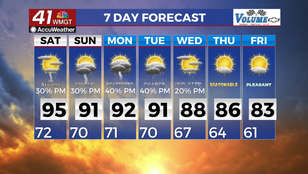
MACON, Georgia (41NBC/WMGT) – Weakening high pressure with moisture slowly increasing through the weekend. The weakening ridge/wedge will allow moisture to increase across the state 


from the northeast. This will increase precipitation chances later this evening. There is a weak backdoor cold front across the Mid-Atlantic states which pushes south today. There is a decent amount of low to mid level moisture ahead of the front, across the Carolinas which will move into North Georgia. Dewpoints increase across North Georgia into the upper 60s to lower 70s. Combined with temperatures in the lower to middle 90s and an axis of moderate instability we will see isolated to scattered showers and thunderstorms this evening mainly across north portions 


of Middle Georgia. Any storms that develop the greatest threat will be strong gusty winds. Moisture continues to increase from the northeast through Saturday increasing precipitation chances across the entire area. Temps also stay in the 90s through the short term period so a similar threat of severe storms continues into the weekend. From the end of the weekend through early next 
week, a closed low will remain parked over the eastern Gulf. Warm and moist air wrapping around the low from the Atlantic will pool across the area, supporting scattered showers and storms each day. High temperatures will remain in the 90s, combining with dewpoints in the 70s to drive heat index values into the upper 90s to low 100s.