Gloomy conditions continue Wednesday
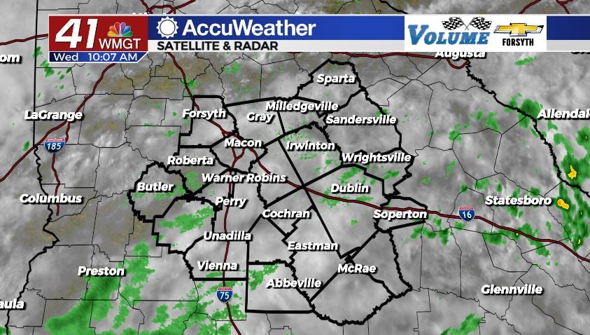
MACON, Georgia (41NBC/WMGT) – Overcast skies, light showers, and isolated thunderstorms will stick around Middle Georgia Wednesday.
Today


We saw a number of small scattered showers around Middle Georgia during the early morning hours today, however many of them began to weaken and fade out as the sun rose. We are still seeing a handful of light showers as we push into the later morning hours, and one or two of them may stick around into the afternoon hours. The early rain along with cloudy conditions are once again keeping high temperatures on the cooler side around Middle Georgia as highs peak in the low to mid 80s. Ambient winds for today will blow out of the southwest at approximately 5 mph.

Later this afternoon a few isolated storms are likely to fire up, however much of Middle Georgia will likely stay dry. Any storms that do form, however, can bring heavy rain, frequent cloud to ground lightning, strong wind gusts, or some small hail. Storm activity will likely be limited to the afternoon and evening hours, and we should see them taper off shortly after sunset.


Overnight conditions will just be cloudy early on (once the evening storms have subsided), however rain will remain in the forecast. After midnight models are hinting at the potential for widespread stratiform rainfall to move into Middle Georgia between 2am and 4am ET Thursday morning. This rain will likely still be hanging around for many parts of Middle Georgia by the time the sunrise arrives in the region. There is, however, the off chance we get missed by all of this rain. Last Thursday morning we were forecast to receive an inch or more of rainfall across much of the region, but instead the widespread rain missed Middle Georgia to the south. Low temperatures will be in the lower 70s and upper 60s regardless of whether or not the widespread rain hits or misses the region.
Tomorrow


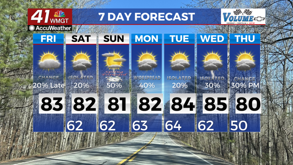
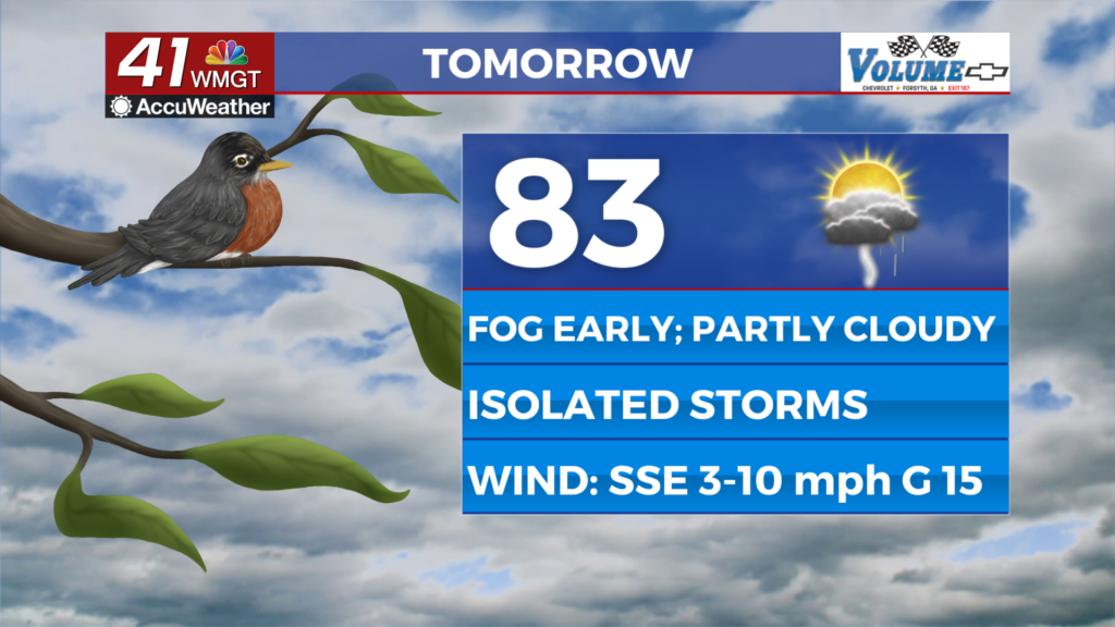
Following the heavy rain (or not) tomorrow morning, more rain is likely to continue ahead of lunchtime. This likely hinges on whether or not the first mass of rain impacts Middle Georgia. If the first mass of storms misses, more than likely the second one will too, resulting in just a cloudy and humid start to the day. Whether or not the rain arrives tomorrow will also impact our high temperatures. Early rain will keep things cooler, leading to highs mainly in the lower 80s with some in the upper 70s. If the rain misses, highs will be in the low to mid 80s.

Regardless of early rain or not isolated thunderstorms will be possible tomorrow afternoon. Similar to today any storm can bring heavy rain, hail, strong winds, or frequent lightning. Those who do not see storms in the afternoon or evening will continue to observe overcast skies.


Overcast skies will persist into tomorrow night, and a couple of isolated showers may hang around the area as well. Overnight rain activity should not be anywhere close to what comes through overnight Wednesday into Thursday, unless, of course, the mass of moderate to heavy rain misses the region once again. Lows will mainly be in the lower 70s.
Friday and Beyond


Friday should see the return of a few pockets of sunshine in the afternoon, however clouds will still dominate. Early showers and the abundant cloud cover will once again limit high temperatures to the mid 80s. Scattered storms will be likely throughout the afternoon and evening hours, however we shouldn’t see much rain overnight as the stationary front that has been over the southeastern US all week breaks down.
Saturday we will see a pretty even split of sun and clouds with a slight edge likely still going towards the clouds. Highs will warm into the upper 80s, and some isolated storms will populate the afternoon and evening skies. A handful of clouds will stick around into the overnight hours as well.
Sunday should also see a relatively even split of sun and clouds, however the edge should finally go to the sunshine, resulting in high temperatures reaching back above the 90° mark. Again a few isolated storms will be possible in the afternoon and evening.
Next week we will begin to see a lot more sunshine sticking around the area, bringing the summer heat back to Middle Georgia as highs stick in the upper 80s and lower 90s. Rain chances look to be pretty low as well, at least early on in the next work week.

The tropics are continuing to heat up as the NHC is watching a pair of potential threats. The first one is a disorganized cluster of showers off to the east-southeast of the Lesser Antilles and has a 20% chance for development in the next 5 days. The second one is a tropical wave coming off of the western coast of Africa and shows a bit more organization at this time. Still, the NHC is only giving it a 20% chance for development in the next 5 days at this time.

Follow Meteorologist Aaron Lowery on Facebook (Aaron Lowery 41NBC) and Twitter (@ALowWX) for weather updates throughout the day. Also, you can watch his forecasts Monday through Friday on 41NBC News at Daybreak (6-7 a.m.) and 41Today (11 a.m).