


First cold front of the week moves through today
MACON, Georgia. (41NBC/WMGT) – The first of two cold fronts this week is pushing through Middle GA this morning.
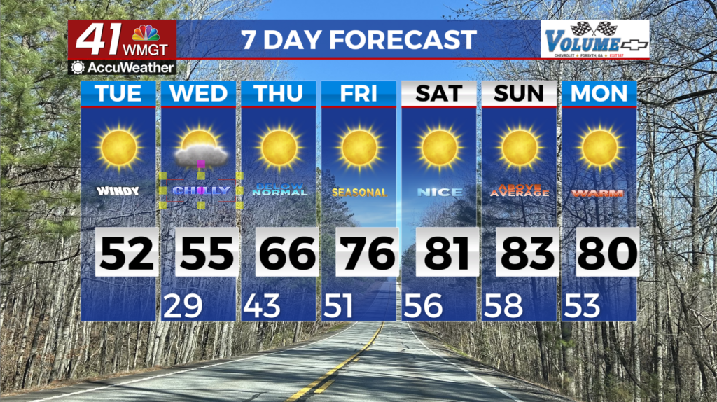
Today
Wednesday was off to a wet start in Middle GA with a cold front and line of thunderstorms just to the north of the region and scattered showers throughout the region. The cold front arrived quickly with heavy rain making its way into Monroe, Baldwin, and Hancock counties ahead of the sunrise. The line of storms should be through Middle GA (or close to it) by lunchtime. Unfortunately for the southern parts of Telfair and Wheeler counties there is a level 1 Marginal risk for severe weather today. This will be when the cold front arrives during the early lunchtime hours. The cloudy skies will hang around most of the day, however; clearing isn’t likely for most of the region until the dinnertime hours. Those further north in locations such as Forsyth or Macon will have a better chance to see sunshine before the sun sets. Temperatures this afternoon across the region will top off in the low to mid 60s. For some locations the difference between the early morning temperatures and the afternoon highs will be negligible thanks to the overnight insulation.

Tonight skies will be clear as wind shifts to the north-northwest at about 5-10 mph. It will also be the coolest night of the week and the only one where temperatures will drop below 40 degrees for most of Middle GA. Lows heading into Thursday morning will be in the upper 30s around the region, though a couple of spots may remain above the 40 degree mark.
Tomorrow
Thursday will arguably be the calmest day of the week as well as the driest. Wind will shift to the southeast at about 5 mph ahead of lunchtime and cloud cover will quickly fill back in after a clear night. The clouds expected for Thursday, however, are primarily high level clouds. Blanket conditions are expected, but a few pockets of sunshine will be possible here and there. High temperatures will continue the mild trend topping off again in the low to mid 60s across the region. A stray shower or two will be possible in the afternoon, but more than likely the rain will hold off until after midnight heading into Friday. Cloudy skies will persist overnight and low temperatures will respond accordingly, warming into the upper 40s and lower 50s around Middle GA. Rain chances will increase drastically heading towards the sunrise as widespread showers move in on Friday.
Friday
Friday will be the most humid day of the work week. A warm front will move through Georgia, warming highs in Middle GA into the low to mid 70s by Friday afternoon. This is all despite cloudy skies and widespread shower activity through the afternoon hours. Winds will blow from the south at 5-10 mph, adding more moisture to an already saturated atmosphere. Overnight lows will be on the warm side as well as temperatures only drop into the upper 50s and lower 60s, about 20 degrees warmer than just two nights prior. This is setting the stage for cold front number two which will arrive on Saturday.
Saturday
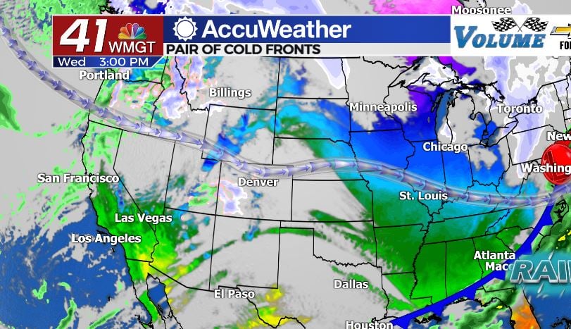
Saturday is the day to remain weather aware in Middle GA. Yes, this is four days out. But most other systems that have come through this fall season hinting at severe weather have not held up even a week out from the event. Now we are less than 4 days away and weather models are in agreement about the potential for severe weather. There are still details that need to be ironed out, however.
Let’s talk setup: the atmosphere is going to be absolutely juiced with moisture thanks to rain from Friday. Dewpoints around the region will likely be in the upper 60s. There is going to be plenty of heat to work with as temperatures around Middle GA climb into the mid to upper 70s. This means humidity values are going to be hovering around the 90% mark for much of the region. Add in a cold front that is expected to drop temperatures from the mid 70s into the lower 40s and you get plenty of instability with cold air aloft arriving quickly. There also looks to be a good amount of wind shear (change in wind direction and speed w/height) ahead of the cold front as well. This unfortunately does support the development of rotating thunderstorms which in turn can spawn tornadoes. Should the skies remain cloudy all day on Saturday as the forecast calls, however, the instability will be limited and so will the severe threat.

At this time the SPC has not issued any risks for Georgia in terms of severe weather on Saturday, but that is only because it is currently more than three days out. There is a level 2 Slight risk in place for the Mississippi River Valley on Friday, however, and with that system arriving in GA the next day it can be looked at as a guide. The SPC will at minimum put out a Level 1 Marginal Risk for Georgia, but there is also time between now and Friday for them to upgrade the risk on Friday to Enhanced if they see fit.
Once the cold front has moved through Saturday evening, the clouds will clear overnight and clear skies and highs in the 50s will return Sunday.

Follow Meteorologist Aaron Lowery on Facebook (Aaron Lowery 41NBC) and Twitter (@ALowWX) for weather updates throughout the day. Also, you can watch his forecasts Monday through Friday on 41NBC News at Daybreak (6-7 a.m.) and 41Today (11 a.m).

Leave a Reply