Fire weather threats continue Wednesday
MACON, Georgia (41NBC/WMGT) – Fire threats remain high in Middle Georgia as temperatures soar and dew points remain low.
Today


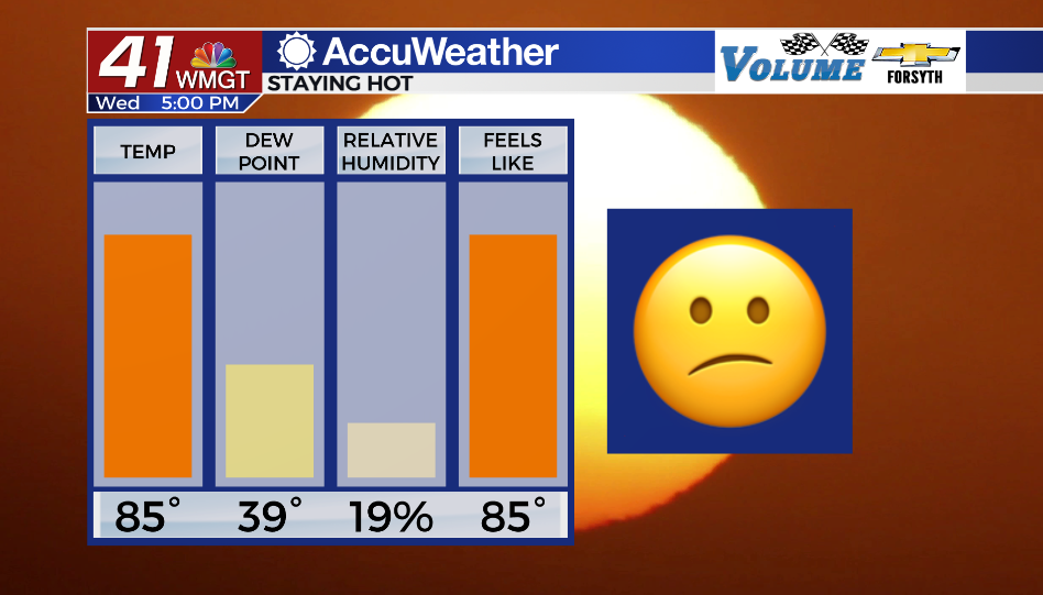
Sunshine continues to stick around Middle Georgia as temperatures climb into the mid 80s this afternoon. Winds have shifted to the southeast (around 5 mph) thanks to high pressure moving out of Georgia to the east. This will allow moisture to slowly return to the atmosphere ahead of Friday night/Saturday morning’s cold front. For today, however, that moisture content remains low as dew points stay in the upper 30s and lower 40s. This results in relative humidity below 25% across Middle Georgia this afternoon which has prompted the NWS to once again issue a Special Weather Statement in regards to High Fire Danger until 8PM EDT this evening.


Skies will remain clear overnight as the winds persist out of the south-southeast at 5-10 mph. Dew points should rise into the upper 40s and lower 50s ahead of tomorrow morning. Low temperatures will drop into the low to mid 50s. These two ingredients (along with winds approaching calm) could lead to a bit of patchy fog out the door.
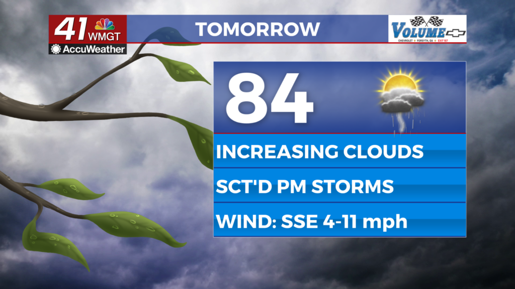
Tomorrow


A mostly sunny day awaits Middle Georgia Thursday as temperatures reach into the mid to upper 80s. Dew points will slowly rise throughout the day as the southeasterly winds continue at about 5-12 mph. This should be the first day this week without High Fire Danger thanks to the returning moisture, however it should not be a humid afternoon by any means. Some scattered cumulus clouds will be possible during the afternoon hours, but there will be no rain to accompany them.


Conditions may feel a little more sticky as Friday morning draws on thanks to the increasing moisture content. Both low temperatures and dew points will be in the mid to upper 50s come Friday morning, bringing an even better chance for patchy fog in parts of Middle Georgia. The winds will continue to feed in from the south-southeast at about 5-10 mph.
Friday and the Weekend


Friday will begin on a sunny note (a layer of low level clouds during the sunrise hours is possible, however) before upper level clouds begin to move in later in the afternoon. Temperatures will top off in the mid 80s around the region with dew points likely rising into the lower 60s; so it may feel slightly muggy during the afternoon. Winds will largely blow out of the south-southeast again before shifting towards the southwest overnight. Cloud cover will thicken overnight as well with a cold front entering the Peach State ahead of the sunrise on Saturday.

Saturday will start off a bit wet as the front enters the region with scattered showers and few storms remaining possible into the early afternoon hours. While its technically still too far out to make a call on severe weather threats the timing of the frontal passage as well as the parent low pressure being located over the great lakes should hamper that possibility a bit. The limited moisture return over the back half of the week could also limit overall storm chances for the region.
Sunday will see mostly sunny conditions with more cirrus clouds entering the region heading into the overnight hours.

Follow Meteorologist Aaron Lowery on Facebook (Aaron Lowery 41NBC) and Twitter (@ALowWX) for weather updates throughout the day. Also, you can watch his forecasts Monday through Friday on 41NBC News at Daybreak (5-7 a.m.) and 41Today (11 a.m).