
Fire weather threats are up as the year comes to a close
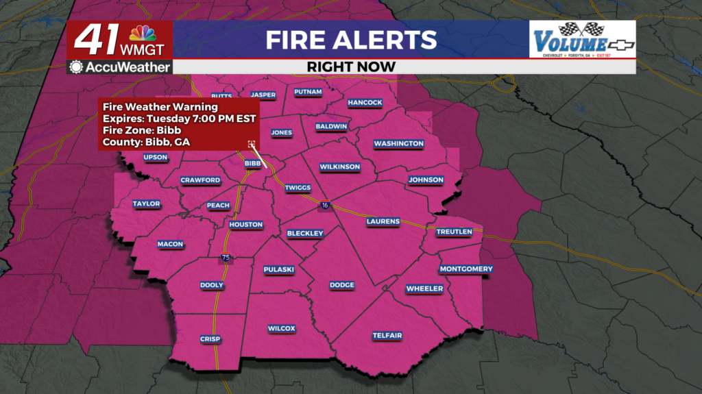
MACON, Georgia (41NBC/WMGT) – Ample wind and low humidity is leading to an increased threat for fires around Middle Georgia heading into New Year’s Eve.
This Evening
It’s been a cool and windy day around the region and another frigid night is on deck, however the wind shouldn’t be quite as strong. Currently a Red Flag Warning is in effect until 7 PM EST due to these strong winds. Gusts will likely reach to around 15 mph overnight as sustained speeds range from 5-10 mph still from the northwest. Overnight lows will again be below freezing with most spots likely in the upper 20s. This should be the coldest night of the week.
Tomorrow
New Year’s Eve will be sunny and cool though a bit warmer than Tuesday. Highs should reach into the mid to upper 50s accompanied by west-northwest winds at around 5-12 mph. Gusts should range between 15-20 mph. Another round of fire weather alerts will be possible, especially with many planning to shoot fireworks off to celebrate the year’s end.


Overnight will be mostly clear and once again pretty cold as temperatures should still dip to around freezing ahead of Thursday morning. Wind will finally shift a bit to out of the west-southwest at 5-10 mph.
The New Year
A warming trend will continue as temperatures should reach into the lower 60s for the first day of 2026. There will be plenty of sunshine for that day as well, however come Friday cloud cover will be much more dominant. Rain odds will increase Friday evening and likely linger through parts of Saturday.

Follow Chief Meteorologist Aaron Lowery on Facebook (Aaron Lowery 41NBC) and X (@ALowWX) for weather updates throughout the day. Also, you can watch his forecasts Monday through Friday on 41NBC News at 4, 5, 5:30, 6, and 11 p.m.