Fire weather risks up for Middle Georgia Monday
MACON, Georgia (41NBC/WMGT) – Plenty of sun and heat are expected across Middle Georgia this week as high pressure dominates the Southeastern US.
Today


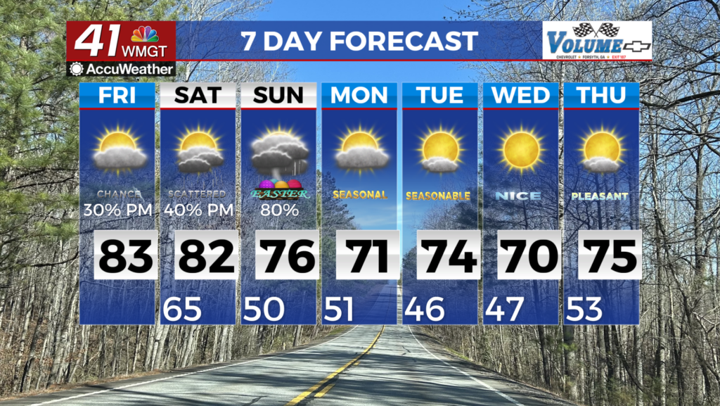
Following a relatively cloudy weekend Middle Georgia saw the sun return bright and early Monday. A few clouds still remained during the sunrise hours, but those have since moved out to to the east. Clear conditions are expected most of the afternoon as temperatures rise into the low to mid 70s. This will be the coolest afternoon of the week. That is largely due to northwesterly winds of 10-15 mph gusting upwards of 25.


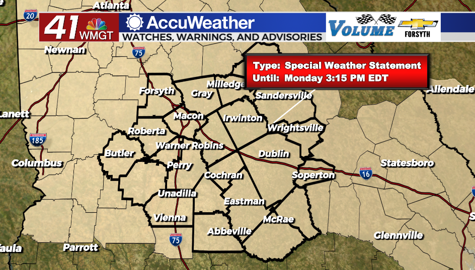
These winds, along with relative humidity values below 25% have prompted the National Weather Service to issue a Special Weather Statement in regards to fire weather. While today’s weather (or most of the week) would be conducive for things like grilling, Middle Georgians need to be responsible. The UV Indexes around the region this afternoon will likely range from 9-10, so sunscreen is necessary for anyone with extensive plans outdoors.


Tonight conditions will stay clear as the winds back off to about 5-10 mph from the northwest. Temperatures will drop into the mid 40s ahead of the sunrise tomorrow morning. Fog is unlikely as dew points stay in the lower 30s along with wind gusts that could still reach 15+ mph.
Tomorrow


Sunshine will abound again Tuesday afternoon as temperatures rise into the upper 70s and lower 80s. Winds will still be out of the northwest, however this time they will barely be noticeable as they hover around the 5 mph mark. UV Indexes will likely hover around 10 during the afternoon, so once again sunscreen will be a must. Cloud cover, much like Monday, will be very hard to come by.


Skies will stay clear through Tuesday night as well, however low temperatures should make a jump into the upper 40s and lower 50s thanks to the winds becoming variable. While patchy fog will be possible heading into Wednesday morning, it will still be unlikely.
Wednesday and Beyond


High pressure will finally begin to exit the region and into the Atlantic as we head into Wednesday afternoon. Temperatures will peak in the mid 80s around Middle Georgia with south-southeast winds blowing in at about 5 mph. A few clouds could pass over during the afternoon, but we will see no rain.
Sunshine should stick around at least into Friday afternoon before cloud cover begins to ramp up in the evening. Moisture return will be limited ahead of the weekend thanks to the high pressure, however that does not mean we will avoid all rain chances. Some showers and perhaps a few thunderstorms will be possible as we go from Friday into Saturday (potentially longer depending on how fast the next cold front moves through).

Follow Meteorologist Aaron Lowery on Facebook (Aaron Lowery 41NBC) and Twitter (@ALowWX) for weather updates throughout the day. Also, you can watch his forecasts Monday through Friday on 41NBC News at Daybreak (5-7 a.m.) and 41Today (11 a.m).