


Dry weather returns briefly Thursday
MACON, Georgia. (41NBC/WMGT) – Middle GA will see a break in the rainy trend this week in the wake of the first cold front
Today
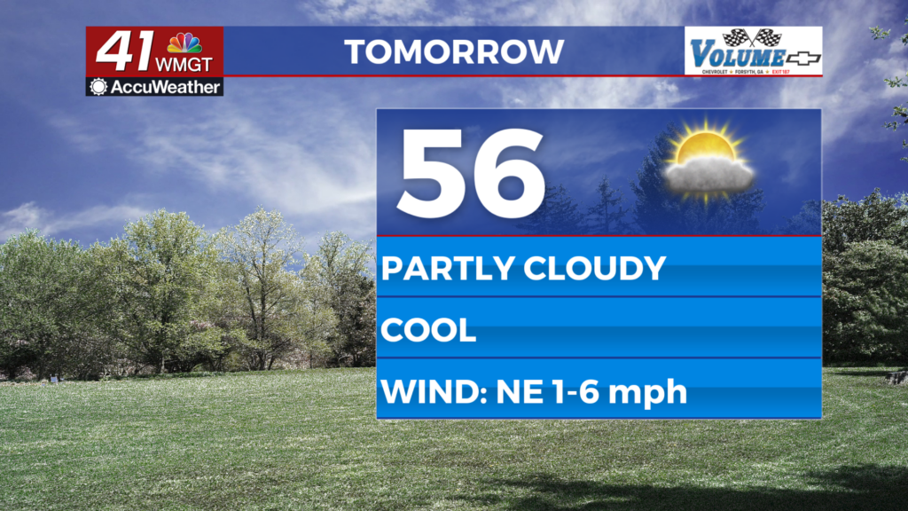
Dry weather does not mean clear skies. We may have woken up to foggy conditions with clear skies overhead in much of Middle GA, but those clouds will be filling back in quickly. The wind has shifted right back to the southeast as we head into the back of the week, pumping warm and moist air right back into the Georgia atmosphere right after a cold front pushed it out late Wednesday. The mild high temperature trend continues yet again as things top off in the upper 50s and lower 60s this afternoon. Rain is unlikely during the daylight hours today, hence the dry weather, but showers will begin to move into the region overnight.
Once midnight passes, showers will become more numerous and the rain intensity will also pick up. With mostly cloudy skies and winds blowing from the southeast, low temperatures will increase greatly from this morning, falling only into the upper 40s and lower 50s heading into Friday. There will likely be several showers around Middle GA with light to moderate rainfall around sunrise on Friday, and some areas may see a cell with heavy rain. Wind will shift to the south heading into Friday morning as well.
Friday
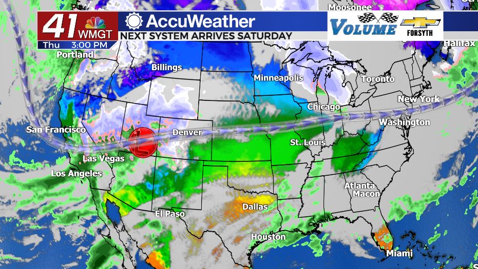
Another cloudy day awaits Middle GA for the final day of the week. The next storm system draws closer from the west with thunderstorm activity moving into the Southeastern US beginning Friday night. Showers will be widespread around Middle GA on Friday, particularly during the first half of the day. A few stray showers will linger into the evening with a few more popping up heading into the overnight hours. Temperatures will jump 10+ degrees in the afternoon despite the showers and overcast skies. A warm front associated with the next weather system will be driving southerly winds at 5-10 mph through the region, adding even more heat and moisture to the atmosphere. Highs will be in the low to mid 70s across the region with low temperatures only falling into the mid 60s. A few showers may persist into Saturday morning.
Saturday
The fun day is Saturday as the next storm system arrives. The atmosphere will be pretty juiced ahead of the next cold front with high temperatures expected to reach into the upper 70s with dewpoints in the upper 60s and low 70s. It will feel like an absolute sauna out there ahead of the cold front’s arrival in the evening. And unfortunately severe weather is still on the table. The SPC has upgraded the risk for the Mississippi Valley late Friday/early Saturday from a Level 2 Slight Risk to a Level 3 Enhanced Risk. At this time the outlook for Saturday in Georgia is a Level 1 Marginal risk for the northern half of the state, but given the recent bump up just to the west, it wouldn’t be too surprising if the SPC bumps up part of GA to Slight on Saturday.
The more cloud cover on Saturday the better the chances are to avoid severe weather. This can be further amplified if there is a lot of shower activity ahead of the main line of thunderstorms. The atmosphere works like an instapot when it comes to severe weather; there’s a “cap” that keeps everything calm until it is broken, and then there’s plenty of energy for storms once it does. Those areas that see more sunshine ahead of the cold front will have more instability at the surface and therefore more energy to break the cap, increasing the chance for severe weather. Cloud cover has caused several severe weather forecasts to bust simply because the cap never broke, preventing major storms from forming.
The cold front is likely to move through Middle GA around or after the sunset on Saturday with rain potentially hanging around to about midnight. Cloud cover will clear from there as winds shift from the south-southwest at 15-20 mph to the northwest at 10-15 mph. Those southerly winds during the day will be adding some extra energy to the system just ahead of the cold front, continuing to juice the atmosphere until it passes. But once it does, as mentioned above, clouds will clear leading into Sunday morning. Low temperatures will respond by falling into the mid to upper 40s around the region. Sunday will see sunny skies with high temperatures returning to the upper 50s and lower 60s around the region with overall drier conditions sticking around into next week.

Follow Meteorologist Aaron Lowery on Facebook (Aaron Lowery 41NBC) and Twitter (@ALowWX) for weather updates throughout the day. Also, you can watch his forecasts Monday through Friday on 41NBC News at Daybreak (6-7 a.m.) and 41Today (11 a.m).


Leave a Reply