Dry and hot conditions continue for Middle Georgia Tuesday
MACON, Georgia (41NBC/WMGT) – High pressure moving into the Peach State will keep things hot and dry Tuesday.
Today


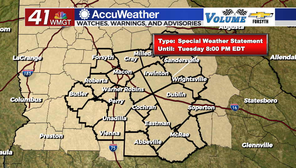
Conditions were clear and chilly to begin Tuesday in Middle Georgia. Now things are still clear, however it is warming up rapidly. Temperatures are expected to climb into the lower 80s across the region this afternoon. This is despite gentle winds out of the north that will hover around the 5 mph mark. Relative humidity values will be below 20% in many spots during the peak afternoon hours, so the National Weather Service has once again issued a Special Weather Statement in regards to High Fire Danger until 8:00 PM this evening. If the winds were stronger, this would likely be a Red Flag (Fire Weather) Watch. UV indexes around the region will again range from 9-10 during the afternoon, so Middle Georgians planning to enjoy the pleasant outdoor conditions should wear protection.


Skies will remain clear during the overnight hours as well as high pressure begins to move into the eastern parts of Georgia and South Carolina. This will result in the winds being light and variable throughout the night. Temperatures will bottom out in the upper 40s and lower 50s, however with dew points hanging in the upper 30s and lower 40s we will see no fog to begin Wednesday.
Tomorrow


Wednesday will be another hot and sunny day around the region as temperatures max out in the mid 80s around the region. Dew points, however, will hang in the lower 40s during the afternoon, once again resulting in relative humidity that is under 20% for much of Middle Georgia. Expect another High Fire Danger day around the region despite the shift in the wind to the south-southeast at around 5 mph.


Skies should stay clear through the overnight hours again across the region, however with winds out of the south-southeast at 5-10 mph moisture will begin returning to the atmosphere. Low temperatures will be in the low to mid 50s with dew points in the upper 40s. This is likely still too much of a gap for fog (esp given the winds), but this will be the first overnight/morning in which its realistically possible this week.
Thursday and Beyond


Thursday will also see sunny skies around Middle Georgia with high temperatures peaking in the mid to upper 80s. Some cloud fields during the afternoon will be possible as moisture continues to slowly return to the region following the high pressure moving out to the Atlantic. South-southeast winds of about 5-12 mph will persist throughout the day with gusts reaching upwards of 18 mph.
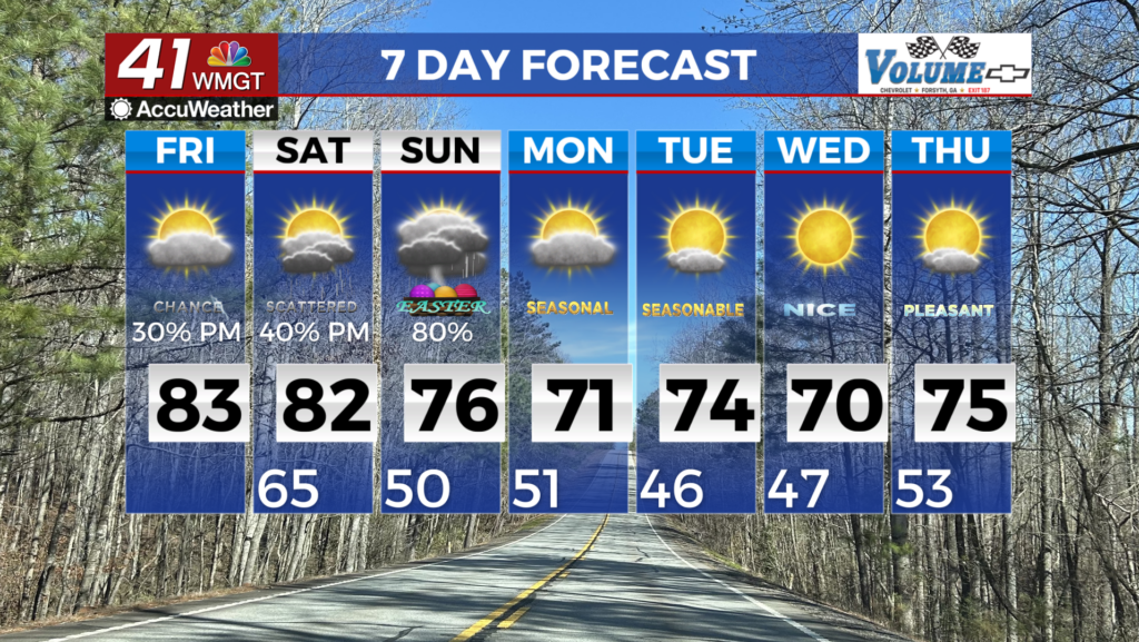
Friday is when some actual cloud cover will return to Middle Georgia as cirrus clouds move in during the afternoon ahead of thicker clouds during the evening and overnight. It will still be a warm afternoon with highs again in the mid 80s, however this time around the region will likely see heat indexes as the humidity continues to increase. Overnight a cold front will arrive in the Peach State with arrival in Middle Georgia likely ahead of the sunrise. Storms could stick around into the afternoon. It is too far out at this time to determine whether or not there will be a severe risk with this system.

Follow Meteorologist Aaron Lowery on Facebook (Aaron Lowery 41NBC) and Twitter (@ALowWX) for weather updates throughout the day. Also, you can watch his forecasts Monday through Friday on 41NBC News at Daybreak (5-7 a.m.) and 41Today (11 a.m).