


Cool and cloudy Friday; snow odds increasing for Saturday
MACON, Georgia (41NBC/WMGT) – Cloud cover will be abundant and temperatures will remain below average ahead of another winter weather system this weekend.
This Evening
Clouds have been increasing throughout the afternoon, however a bit of clearing will be possible overnight. Expect sub-freezing temperatures for lows once again however they should stay warm enough to where Middle Georgians don’t have to drip the faucets. Make sure to bring in any outdoor pets or plants though! The wind will be light and variable.
Tomorrow
Friday will be mostly cloudy from the get go with overcast conditions becoming more likely in the evening. Temperatures will largely reach the low to mid 50s however the warmest spots may creep towards 60 degrees. The wind will be variable though generally out of the south through the afternoon. Rain odds will be low but a stray shower in the evening is possible.


Those rain odds will begin to uptick during the overnight hours, especially after midnight. The wind will suddenly shift to out of the north-northwest and suddenly increase as well. Expect gusts to be pushing close to 25 mph rolling into the sunrise on Saturday accompanied by temperatures dropping below freezing. The aforementioned rain showers should shift into snow during sunrise on Saturday as well.
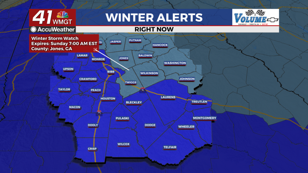
Saturday: The Snow
Saturday will be a blustery and snowy day for much of Middle Georgia. Snow will be heaviest and most persistent in the northeastern counties. At this time several of those are under a Winter Storm Watch until 7:00 AM on Sunday morning. A few snow showers will be possible in the furthest west counties as well, however accumulations are not currently expected in those areas. Those under the watch can expect at least an inch with counties such as Hancock or Washington getting upwards of 3 inches. To go along with this snow the wind will be powerful out of the northwest. Sustained speeds may range anywhere from 10-25 mph and gusts anywhere from 25-40 mph. This will make visibility rather low while snowfall is occurring.


Snow should taper off in the evening however the wind will remain voracious. Sustained speeds will still range from 10-20 mph with gusts in that 20-35 mph range. Temperatures will plummet into the mid to upper teens across the region, so almost all snow that falls Saturday afternoon will stick through into Sunday morning. An Extreme Cold Watch is in effect for the entire region until 1:00 PM on Sunday to account for these frigid temperatures. Middle Georgians will need to drip the faucets overnight Saturday into Sunday.
Sunday and Beyond: Sunshine and Wind
Those who typically travel on Sunday mornings should expect slick and snowy roads as well as plenty of wind to go with that. However the sun will be out all day and so melting should begin during the late morning hours as temperatures begin to climb above freezing. Even with temperatures expected to reach the upper 30s and lower 40s Sunday afternoon it will be a frigid one as the northwest winds continue at 10-17 mph (gusting as high as 30 mph). This wind will bring drier air into the area, however, so it should also help the melting process. Expect clear skies overnight Sunday into Monday with temperatures dipping into the upper teens and lower 20s by Monday morning. Some black ice and residual snow may linger depending on accumulations from Saturday, so travel Monday morning may be a bit hazardous. Anything left should melt Monday afternoon, however.

Follow Chief Meteorologist Aaron Lowery on Facebook (Aaron Lowery 41NBC) and X (@ALowWX) for weather updates throughout the day. Also, you can watch his forecasts Monday through Friday on 41NBC News at 4, 5, 5:30, 6, and 11 p.m.
