Conditions stay warm into the weekend; next cold front in sight
MACON, Georgia (41NBC/WMGT) – Temperatures will remain almost 20 degrees above average through the weekend before a cold front arrives Monday.
This Evening
Following a cloudy start to the day the sunshine has worked to come out this afternoon and evening. Cloud cover will fill back in overnight, however, and some fog will be possible as well. Expect low temperatures to largely be in the upper 50s with a few spots possibly staying over 60 degrees. The wind will be light out of the southwest with the occasional gust pushing to 10-15 mph.
Tomorrow
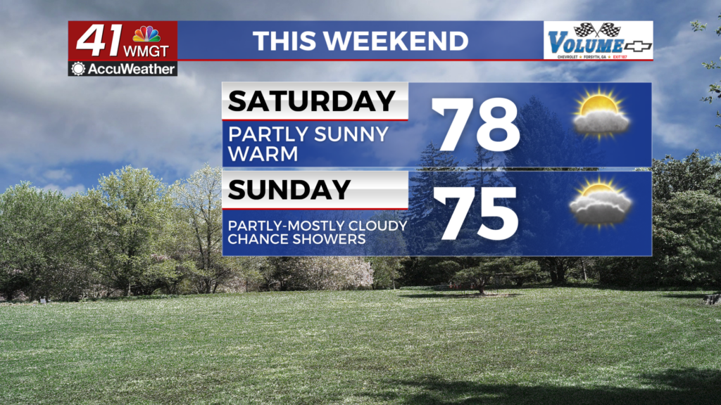
A partly cloudy day is likely for the first half of the weekend with highs pushing towards the 80 degree mark. A few spots may reach or even eclipse 80 degrees. The wind will be out of the west at around 5-10 mph with gusts to around 15 mph.


Overnight will be mostly cloudy with low temperatures once again likely in the upper 50s and lower 60s. The wind will be light and variable. Fog is likely rolling into Sunday morning.
Sunday and Beyond
Sunday will likely be mostly cloudy and possibly overcast in some spots. Temperatures will peak in the mid to upper 70s accompanied by wind that will begin out of the southeast in the morning at 5-10 mph but shift to the southwest in the afternoon in the 10-15 mph range. Gusts could push over 20 mph over the latter half of Sunday. A few showers will also be possible in the afternoon and evening, however many spots will stay dry.

Rain odds will be higher on Monday as the cold front finally passes through the Peach State. This will lead to temperatures that are more winterlike for much of next week.

Follow Chief Meteorologist Aaron Lowery on Facebook (Aaron Lowery 41NBC) and X (@ALowWX) for weather updates throughout the day. Also, you can watch his forecasts Monday through Friday on 41NBC News at 4, 5, 5:30, 6, and 11 p.m.