Conditions stay warm and muggy Tuesday
MACON, Georgia (41NBC/WMGT) – Above average temperatures and elevated humidity are expected Tuesday.
This Evening


It’s overall been a mostly cloudy start to the week however some clearing has happened this afternoon. Showers are becoming more widespread as the evening progresses. While thunderstorm activity is not expected a rumble of thunder cannot be ruled out. These should taper off as the sun sets.


Overnight will be partly cloudy with lows expected in the mid to upper 60s. The Full Hunter’s moon will be visible tonight and will be a Supermoon. Wind will stay out of the east at around 5-10 mph.
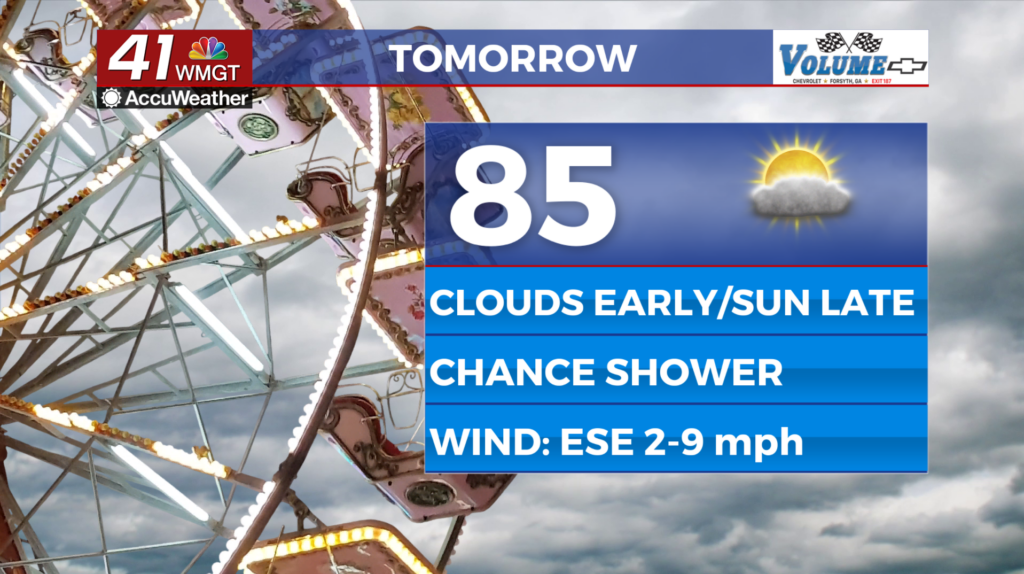
Tomorrow


A cloudy start is likely Tuesday with some clearing expected again through the afternoon. Highs will reach into the mid to upper 80s with real feels likely pushing the lower 90s in the hottest spots. A couple of showers will be possible throughout the afternoon and evening. Wind will flow from the east-southeast at around 5-10 mph.


Overnight will be partly cloudy with lows again expected in the mid to upper 60s. Wind will flow from the southeast at around 5 mph. Fog will also be possible.
Wednesday and Beyond


Wednesday will feature the highest odds for rain this week with showers and a couple of storms possible in the afternoon and evening. It will also be a warm day as highs largely reach the upper 80s. A cold front is expected to arrive Wednesday night, however, dropping highs into the 70s for the last two days of the work week. It should be a sunny weekend accompanied by plenty of wind.
The Tropics


In the Atlantic Basin Invest95L has 80% odds for development over the next 7 days. The next name on the list for 2025 is Jerry. In the Gulf there is also a disturbance but it only has 10% odds to develop within the next week.

Follow Chief Meteorologist Aaron Lowery on Facebook (Aaron Lowery 41NBC) and X (@ALowWX) for weather updates throughout the day. Also, you can watch his forecasts Monday through Friday on 41NBC News at 4, 5, 5:30, 6, and 11 p.m.