Cold snap to end quickly for Middle Georgia
MACON, Georgia (41NBC/WMGT) – The chilly conditions we have seen the last two mornings are leaving Middle Georgia today.
Today


You likely needed a thicker layer out the door this morning than what you would normally wear this time of year. Temperatures plummeted into the upper 30s and lower 40s this morning around the region, bringing what was likely the final taste of winter in 2022. The overall trend the next several days is for above average temperatures to take over the region. Highs for this afternoon are going to be in the upper 70s to kickstart that trend. The wind will lend aide as well as it blows in from the southeast at 7-12 mph. Gusts could reach speeds of 20 mph. Some scattered clouds are likely to begin to fill in as the late afternoon and early evening hours draw on.


Cloud cover will continue to increase as we roll into tonight, thickening after the midnight hour. The wind will remain rather breezy at 8-13 mph from the southeast. Gusts could still reach speeds of up to 20 mph. The stronger winds will lead to mixing of the lower atmospheric layers, moving warmer air towards the surface. On top of that, the added cloud cover and moisture will result in warmer conditions overall. These two factors are going to lead to low temperatures jumping from the upper 30s this morning into the low to mid 50s tonight/tomorrow morning.
Tomorrow


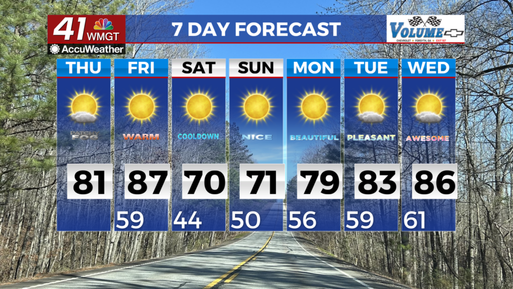
Thursday begins a string of days in which our high temperatures will reach at least 80 degrees (for most of the region, Friday for all). The overall sunny pattern will continue, however the morning will begin with an abundance of clouds. Those will take their time to clear out, however much of the region should begin to see sunshine dominate during the late lunchtime hours. Winds will primarily blow out of the east-southeast at 5-10 mph, a bit calmer than the previous couple of days.


Clear skies will persist through the overnight hours, however the wind will remain steadfast out of the southeast. Even though the cloud cover and added insulation will be gone, and the wind will be calmer, resulting in the air layers not being mixed, low temperatures are still forecast to be warm heading into Friday. This is largely due to the fact that a cold front will not be passing through to change the properties of the airmass over Georgia. Therefore, lows heading into Friday should still be in the lower 50s.
Friday and the Weekend

Sunny skies will persist on Friday as all locations in Middle Georgia warm into the low to mid 80s. Overnight conditions will be mostly clear as lows drop into the low to mid 50s.

Saturday will see sunny conditions as highs warm into the mid and upper 80s. Lows will drop into the mid 50s under mostly clear skies.
Sunday will be mostly sunny with highs in the mid and upper 80s. Lows will drop into the upper 50s under mostly clear skies. Patchy fog will be possible heading into Monday morning.

Follow Meteorologist Aaron Lowery on Facebook (Aaron Lowery 41NBC) and Twitter (@ALowWX) for weather updates throughout the day. Also, you can watch his forecasts Monday through Friday on 41NBC News at Daybreak (6-7 a.m.) and 41Today (11 a.m).