Clouds and rain odds begin to climb tonight
MACON, Georgia (41NBC/WMGT) – A cloudier pattern will takeover the next few days ahead of the next storm system.
The Rest of the Evening


It was a lovely day around Middle Georgia, and the sky cooperated for those who wished to view the Solar Eclipse. Now that that has passed, cloud cover will begin to increase ahead of a storm system arriving later this week. Tonight winds will remain out of the south-southeast at about 5-10 mph, and a few showers will be possible. Temperatures will bottom out in the upper 50s and lower 60s ahead of Tuesday.
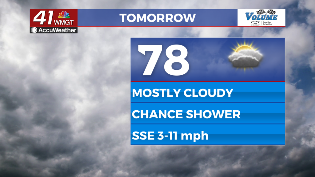
Tomorrow


A mostly cloudy day is expected, however it will be warm and a bit muggy. Highs will reach the upper 70s and lower 80s around the region as the wind continues from the south-southeast at around 5-12 mph. An isolated shower or two will be possible during the afternoon.


Tomorrow night a few showers will also be possible as skies remain cloudy. Expect winds to begin to increase some ahead of Wednesday morning as a warm front arrives. Low temperatures will be in the low 60s around the region.
Wednesday and Beyond


Partly cloudy skies are likely Wednesday afternoon as highs climb into the lower 80s for most of the region. Winds will predominantly come from the south at about 10-17 mph, likely gusting over 30 mph by the evening. A few showers will be possible, also in the evening.


Overnight into Thursday is when the next round of thunderstorms is expected as the next cold front arrives. The Storm Prediction Center has highlighted all of Middle Georgia in a 15% risk zone 4 days out. This will likely translate to a Level 2 severe threat for at least parts of the region. Those will clear out ahead of lunchtime Thursday with strong winds and sun taking over ahead of the weekend.

Follow Meteorologist Aaron Lowery on Facebook (Aaron Lowery 41NBC) and Twitter (@ALowWX) for weather updates throughout the day. Also, you can watch his forecasts Monday through Friday on 41NBC News at 4, 5, 5:30, 6, and 11 p.m.