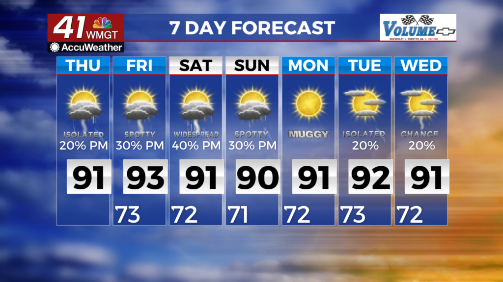
Chances for rain decrease as temperatures increase
MACON, Georgia (41NBC/WMGT) – Heavy rainfall and possible flooding are the primary forecast concerns. The primary factors driving the threat for heavy rainfall are a low pressure system 


 lifting north from Alabama and a weak trough draped across the north Georgia mountains. The interaction between these two features should lead to a zone of convergence north of I-20. As this area develops moisture values should increase above 2 inches, and the combination of lift and ample available moisture could produce hourly rain rates in the 1.5 to 2.5 inch range. This threat appears more pronounced northeast of Atlanta and north of Athens. The threat for prolonged higher rain rates could lead to flash flooding. A lower risk for flooding will exist for Middle Georgia, due to the fact this area is closer to the core of the low moving out of Alabama. Isolated rainfall totals in excess of 4 inches are possible by sunrise on Thursday, although for most locals amounts in the 0.25 to 1.00 inch range are favored. The trough that brought us the isolated heavy rainfall and thunderstorms to the region early this morning shifts into the Carolinas. In its wake, west-northwest flow and weak subsidence develops across Georgia. Unlike in the fall or winter months, when northwest flow would indicate drier conditions, the airmass advected into the state will remain tropical. Therefore additional showers and storms can be anticipated with daytime heating Thursday afternoon. This will also be a limiting factor for storm coverage and timing. Rainfall should be less widespread and the peak in convection may occur in the late afternoon or evening. The exception may be the mountains where differential heating over the terrain could help showers and storms redevelop during the early afternoon.