

Chance for showers ahead of a cold front midweek
MACON, Georgia (41NBC/WMGT) – An overall quiet pattern occurring across the state today ahead of an approaching cold front. Low level cloud cover is prevalent over much of the area with 


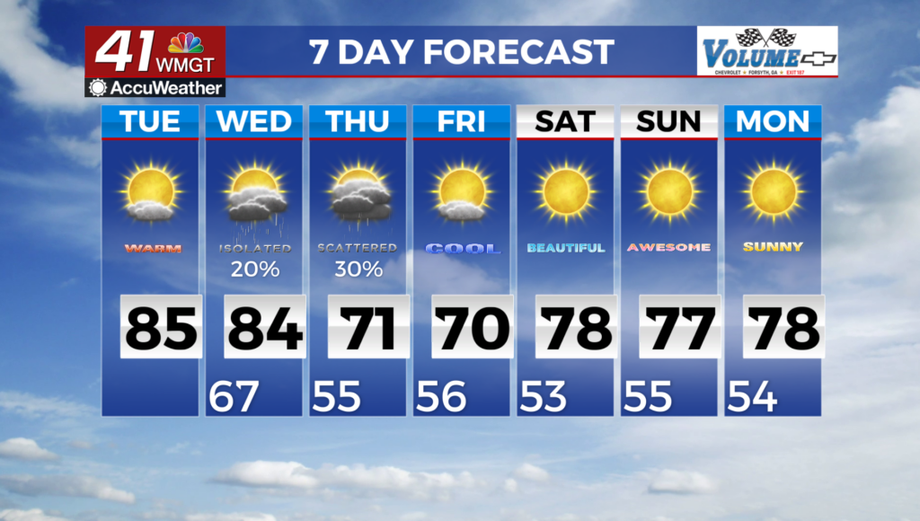
 some clearing over parts of Middle Georgia generally south of Macon and Columbus. High temperatures in the upper 70s with mid 80s where the clouds have broken. Light showers mainly over eastern Georgia. Wind gusts have have tapered off and only low end gusts are expected for today. Troughing over the Upper Plains will begin pushing eastward with a cold front approaching the far northern portions of Georgia Tuesday night into Wednesday morning with precipitation chances elevated due to an expected linear shower/storm line. With the timing of this line, it will be hard to get anything robust storm-wise and will likely stick with just thunderstorms with the potential for maybe one or two strong storms. The extended forecast starts off with a frontal boundary pushing into Northwest Georgia Wednesday morning and slowly moving southeast through the state. This front brings some showers and thunderstorms to the area Wednesday and Thursday however, we are not expecting much in the way of any severe weather. The main low pressure center associated with this front is centered in Quebec, Canada and the deeper moisture, better dynamics, and better instability are well north of the region. The tail end of the frontal boundary sweeps through the area Wednesday and Thursday so we are not expecting much from it. We will have some warm temperatures across the area ahead of the front for this time of the year which will help to mix things up and get some showers and thunderstorms going, but the fact still remains that this front will be moisture starved with rainfall totals expected in the 0.1 to 0.5 inch range. As this front moves through the state another high pressure ridge builds in quickly behind the front pushing into north Georgia Thursday morning. This ridge becomes centered over the eastern Great Lakes states Thursday afternoon and doesn’t really build to fast down into the Southeastern U.S. This will allow the frontal boundary to stall across south Georgia Thursday night into Friday. We could still see some isolated showers Friday across Central Georgia still being close to the old frontal boundary.

