Below average temperatures likely again Wednesday
MACON, Georgia (41NBC/WMGT) – Temperatures will stay a bit cooler Wednesday following the cold front passage Monday night.
This Evening
Partly to mostly cloudy skies are likely through the evening hours with more clouds filling in overnight. A stray shower or two will be possible but overall rain odds are very slim. It will be another mild night with temperatures dropping largely into the upper 40s. The wind will flow from the east at 5-10 mph with gusts reaching as high as 17 mph.
Tomorrow
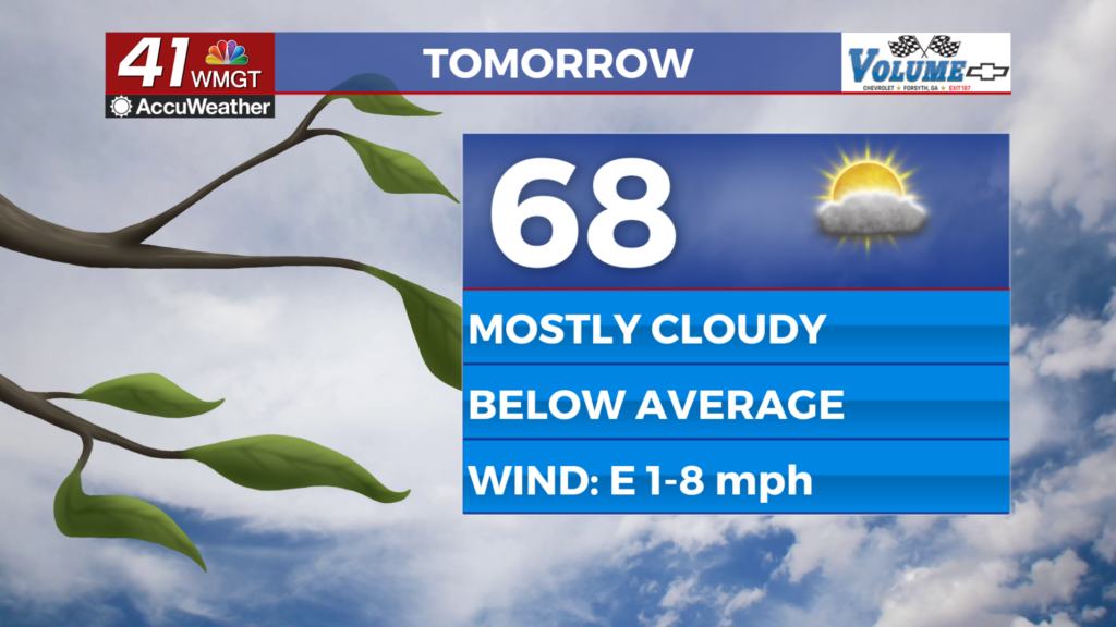
Model guidance has been battling for a week on what the conditions will be for Wednesday and here we are the day before with that battle ongoing. The European model is trending the warmest thinking highs will push into the upper 70s. The American is the opposite, expecting a lot of cloud cover and highs in the upper 50s! Some of the more high resolution short-range models are seeing highs in the mid 60s, but the overall range of possible highs less than 24 hours out is staggering and honestly shouldn’t be happening. Given that conditions have overall been warm lately expect highs to largely be in the upper 60s or lower 70s, trending even warmer if cloud cover ends up more limited than expected. The wind will be light from the east throughout the afternoon. A few stray showers will be possible, however most spots will not see any activity and impacts will be negligible for those that do.


Overnight will see warmer conditions with most spots likely to remain above 50 degrees leading into Thursday. A good chunk of the clouds from Wednesday afternoon will clear out overnight. Expect the wind to shift out of the southeast around 5 mph.
Thursday and Beyond
Temperatures will return into the 80s for most of Middle Georgia by Thursday afternoon as a mix of sun and clouds is likely through the afternoon. The wind will shift to the southwest in the morning flowing at around 5 mph throughout the afternoon. This will lead to continual warming through the rest of the work week before another cold front arrives Friday night.

Follow Chief Meteorologist Aaron Lowery on Facebook (Aaron Lowery 41NBC) and X (@ALowWX) for weather updates throughout the day. Also, you can watch his forecasts Monday through Friday on 41NBC News at 4, 5, 5:30, 6, and 11 p.m.