As rain chances remain low pollen counts begin to rise
MACON, Georgia (41NBC/WMGT) – High pressure over South Georgia will keep rain chances low despite a cold front arriving today.
Today


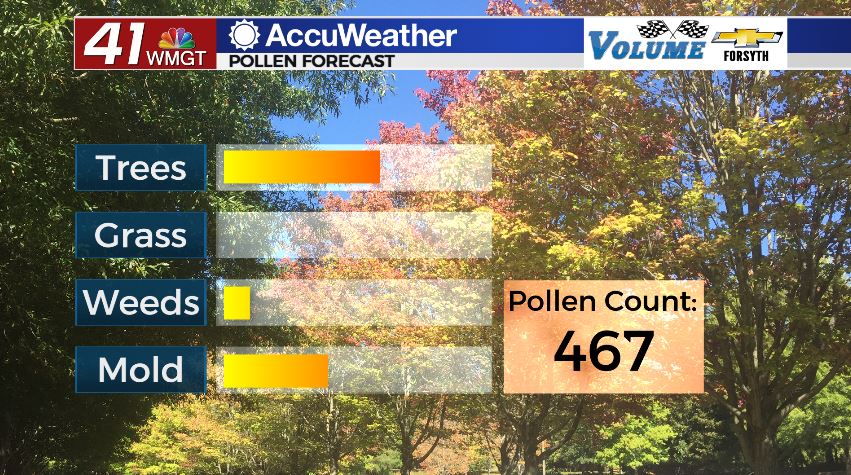
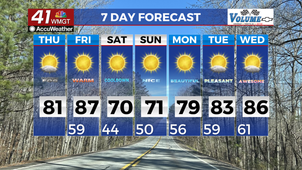
There were a handful of high level clouds around Middle Georgia as the day kicked off with temperatures in the 50s. Winds will blow out of the west-southwest today at about 5-10 mph with gusts up to 15 as highs return to the lower 80s for most of the region this afternoon. A cold front will be arriving later today, however a staunch high pressure system over southern Georgia along with a ridging pattern in the jet stream over the far southeastern US will cause it to weaken on its way here. As a result, we will see cloud cover begin to increase around Middle Georgia this afternoon with the northern counties potentially seeing some blanket conditions. A few isolated showers will also be possible late this afternoon and into this evening in those same counties, but thunderstorms are unlikely and a large temperature drop will be avoided. As a result of the lack of rain pollen levels are rising today with tree pollen being the main culprit. Atlanta Allergy and Asthma has reported a pollen count of 467 for this afternoon.


Overnight skies will remain partly cloudy as conditions stay warm. Showers are unlikely as winds remain out of the west-southwest at about 5 mph. Lows will continue to remain warm as well and for the the 3rd day in a row only fall into the upper 50s.
Tomorrow


Rinse and repeat, right? That’s basically today and tomorrow with the exception of the fact that a cold front will not be coming tomorrow. Highs will warm by a few degrees for peaks in the mid to upper 80s for most of the region, making it the warmest day of the week. Winds will return to the south-southwest at about 5-10 mph with gusts between 15 and 20 mph. Rain is not expected as cloud fields again develop in the afternoon following a relatively clear morning.


The clouds that fill in during the afternoon will begin to clear a bit shortly after sunset, however tomorrow night is anticipated to be the warmest one of the week as winds remain out of the southwest at 5-10 mph. Lows will only fall into the upper 50s and lower 60s as a weak warm front moves through the Peach State,
Friday and the Weekend


Friday will see another cold front arrive as we head into the afternoon hours, and much like Wednesday it will be greatly weakened by the time it reaches the region. Highs will be a bit cooler, mainly topping off in the upper 70s and lower 80s with isolated showers likely to push into the middle counties of the region. Thunderstorm activity is again likely to be avoided thanks to the ever-so-stubborn high pressure off to the southeast. Pollen counts will likely continue to rise as the pollenating season for trees continues to draw closer.

Saturday will see a mix of sun and clouds (yes, again) with more cloud cover building as the day nears its end. Highs will reach the lower to mid 70s as a result of Friday’s cold front, however humidity will remain high heading into Sunday with the best rain chance of the week (excluding this past Monday) still awaits.
Sunday will see rain move in during the afternoon and it will likely hang into the overnight hours and possibly Monday morning. Highs will reach the low to mid 60s with northeasterly winds taking over at 10-15 mph. Thunderstorm activity is not anticipated with Sunday’s rain at this time nor is severe weather.
Monday will see the return of highs in the 60s under mostly sunny skies as we prepare to enter into March.

Follow Meteorologist Aaron Lowery on Facebook (Aaron Lowery 41NBC) and Twitter (@ALowWX) for weather updates throughout the day. Also, you can watch his forecasts Monday through Friday on 41NBC News at Daybreak (6-7 a.m.) and 41Today (11 a.m).


Leave a Reply