Another weekend means more wet weather for Middle Georgia
MACON, Georgia (41NBC/WMGT) – The next weathermaker is on deck for Middle Georgia as we roll into the 2nd weekend of February.
The Rest of the Evening


Mostly cloudy skies will stay with Middle Georgia this evening and tonight in the form of high level stratus clouds. No rain is expected tonight, and wind should remain on the calm side of things. Some patchy fog will be possible thanks to the increasing moisture due to the southerly winds. Temperatures will fall into the lower 50s by tomorrow morning.
Tomorrow


The high level stratus clouds will linger with some mid-level clouds likely to move into the picture more tomorrow afternoon. Highs will reach the low to mid 70s around the region with wind coming from the south-southwest at about 5-15 mph, gusting upwards of 20 mph. A couple of small showers will be possible over the back half of the day, however most of Middle Georgia will stay dry.


Tomorrow night will be overcast with the possibility for showers overall remaining low. Temperatures will be very warm, only falling into the upper 50s and lower 60s. Wind will continue to come from the south-southwest at around 5-10 mph. Shower odds will begin to increase more as sunrise approaches Sunday morning.
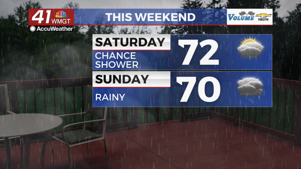
Sunday


Overcast skies will remain Sunday with temperatures climbing into the upper 60s (lower 70s for some southern locations) as the wind continues from the south-southwest around 5-15 mph, gusting over 20 mph. Off and on light to moderate rain is expected through the day with more widespread activity likely over the back half of the afternoon/evening. Overnight expect showers to continue with temperatures only falling into the low to mid 60s ahead of Monday morning.
Monday and Beyond


Thunderstorms are likely Monday afternoon as the cold front finally passes through the region. As of now the SPC has highlighted much of the Peach State for a 15% severe risk on Monday. Middle Georgians will need to be weather aware as risks will likely include strong winds, the possibility for some hail, or a couple of brief tornadoes. Rain should slow overnight Monday into Tuesday, however cloud cover likely will not begin to clear until Tuesday afternoon. Sunnier conditions will be back by Wednesday.

Follow Meteorologist Aaron Lowery on Facebook (Aaron Lowery 41NBC) and Twitter (@ALowWX) for weather updates throughout the day. Also, you can watch his forecasts Monday through Friday on 41NBC News at 4, 5, 5:30, 6, and 11 p.m.