Another round of severe storms is possible this afternoon
MACON, Georgia (41NBC/WMGT) – A second storm system will bring another opportunity for severe weather to Middle Georgia.
Today


It was the warmest morning of the week to kick things off around Middle Georgia today. It was also very humid as much of the region went through the morning with an abundance of fog. Things will remain calm for the first half of the day, however our weather could get a bit rocky this afternoon. We will have plenty of heat today as highs are forecast to be in the upper 70s and lower 80s around the region. There is also a slight chance we could see a break in the clouds as we head into the late lunchtime hours. That could provide extra instability for storms later on.


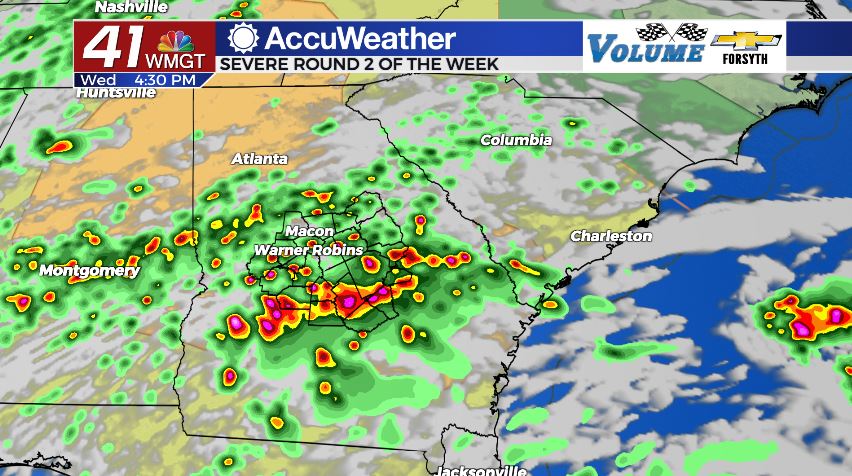
The risk for severe weather around Middle Georgia today has been bumped up to a Level 3 “Enhanced” risk for all counties. Storms are likely to begin to fire up during the late afternoon hours. When they do first fire up, the tornado threat will likely be at its highest. Forecast model’s are currently predicting the development of discrete supercell thunderstorms early on, and those are the type with the track record for damaging tornadoes. These cells are likely to hang around for a couple of hours before more messy thunderstorms begin to take over. There is a flash flooding risk for this afternoon in much of the region as well; a Flood Watch is in effect until 8:00 am Thursday morning.


Tonight we will see the weather calm down, however some scattered storms will persist into the night. A weaker line of thunderstorms will arrive after midnight as the cold front pushes through. We could see some strong wind gusts with that, however it shouldn’t bring any tornado threat. Once that line passes, we will see our winds shift to the northwest to begin to cool things off. Overnight lows will drop into the mid to upper 50s and lower 60s. Additional rain totals through tonight could be upwards of 2″ in some parts of Middle Georgia.
Tomorrow


We will have an abundance of cloud cover overhead as the sun rises on Thursday. A few scattered showers may still remain in some of our southern counties as well. By the lunchtime hours, however, the majority of the region should be seeing sunny skies as the clouds depart to our southeast. Highs will be a bit cooler than Wednesday, only topping off in the low to mid 70s. It will also be notably less humid as the wind comes in from the northwest at 10-15 mph.


Overnight the skies will be completely clear as the winds shift a bit towards the west, now blowing in at 5-10 mph. Temperatures will bottom out in the lower 40s heading into Friday as a cold snap looks to take over for the weekend.
Friday and Beyond
Friday will begin sunny but see a handful of clouds fill in during the afternoon. It will be a windy one as sustained speeds hang in the 15-20 mph range with gusts over 30 mph out of the west-southwest. Highs will reach the mid to upper 60s while overnight lows drop into the upper 30s.
Saturday will almost be a repeat as the day begins sunny and clouds fill in during the afternoon. The wind will still be blustery as sustained speeds blow in at 15-20 mph from the west-northwest. The European model continues to insist on shower chances for the afternoon, but no other models are seeing this. Just like last week, this likely will not happen. Highs will be in the upper 50s and lower 60s and overnight lows will plummet into the mid 30s. Saturday is expected to be the coldest day of the week.
Sunday will continue the sunny Sunday trend once again as highs top off in the upper 60s and lower 70s. The wind will come in from the northwest at 5-10 mph. Lows will drop into the upper 30s and lower 40s.

Follow Meteorologist Aaron Lowery on Facebook (Aaron Lowery 41NBC) and Twitter (@ALowWX) for weather updates throughout the day. Also, you can watch his forecasts Monday through Friday on 41NBC News at Daybreak (6-7 a.m.) and 41Today (11 a.m).