

Another mild day before cold temperatures arrive
MACON, Georgia (41NBC/WMGT) – Morning low temperatures will be in the 40s. Expect precipitation chances to increase (barely) across our far southern tier as a shortwave treks along the 


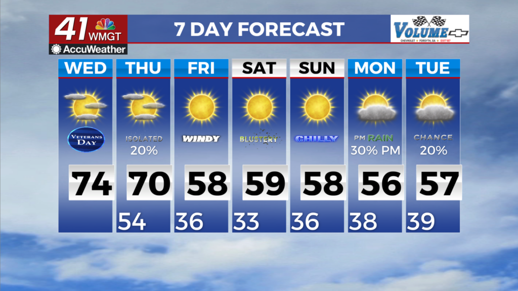
northern Gulf. Currently, we are looking at just 10 to 20 percent chance (bubbling below slight chance) for a passing shower, so most will remain dry. A cold front riding along the leading edge of the northernmost shortwave will breach northwest Georgia late Wednesday afternoon to overnight, bringing with it more concentrated chances for showers and embedded thunderstorms across the northern half of the state. With minimal airmass changes expected, highs will be in the 70s for all but northeast Georgia. Beginning Wednesday night into Thursday morning the front will be pushing into the northwest and through northern Georgia. Thankfully, as this line pushes through it will be overnight and well displaced from the parent low meaning we are unlikely to see any 


strong or severe thunderstorms. With the lack of any blocking features, the front continues to progress through the northern and northeast portions of the state into early Thursday morning with minimal precipitation expected. Following the frontal passage, the overall pattern will continue to showcase a broad trough over the eastern U.S. which may contribute to gustier winds on Friday in conjunction with the post frontal environment. Current guidance suggests wind gusts between 20 to 25 mph but on the higher end, we could see gusts as high as 30 to 35 mph through Friday afternoon. Following the frontal passage and into the weekend, the coldest air of the season will begin to impact much of North and Middle Georgia. Highs this weekend will be in the low to mid 
50s across the area before slowly warming into next week into the low 60s for highs. Lows on the other hand will dip to around or below freezing for much of the area beginning Friday night into Saturday morning and then again Saturday night into Sunday morning. For some areas in North Georgia are expecting to reach below 28 degrees, therefore, this could be the “killing” freeze for agricultural needs. Pushing past the weekend another wave looks to move in early next week which will bring our next chance for rain but uncertainty remains on timing and amounts.