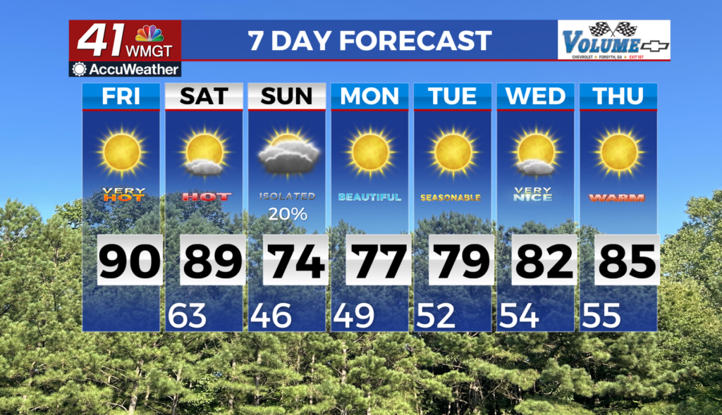
Another hot day ahead before seasonable temps arrive
MACON, Georgia (41NBC/WMGT) – A robust ridge over the Gulf will rebuild over the Southeast U.S. today and into Saturday, lending support to very warm and dry weather. With the center 


 of the ridge axis and the warmest airmass set up over Georgia this afternoon, high temperatures will climb into the upper 80s to low 90s with possible records being tied or broken. Overnight lows tonight will only fall to the low to mid 60s, with temperatures again climbing to the upper 80s to low 90s on Saturday afternoon. The combination of increasing high clouds and the ridge axis sliding off to the east will likely keep high temps a few degrees cooler than today. Increasingly breezy southwest winds during the afternoon will provide some relief, unlike today when winds will be very light. Daily temperature records will be threatened both days across the area. The war and dry airmass over the region continues to create fire weather concerns when combined with the very dry vegetation from the ongoing drought. Humidity will drop to around 25-30 percent across most of the area today, prompting a Fire Danger Statement that will be in effect for this afternoon and evening and a possible issuance for Saturday. Model guidance remains aligned on the passage of a trough across the eastern U.S. late Saturday through late Sunday. An associated low pressure system will drive moisture advection across the southern U.S. along the system’s cold front as it pushes east. The result will be showers with a potential thunderstorm across at least parts of north and Middle Georgia Saturday evening through Sunday morning. Strong winds will accompany the base of the trough, but given such a dry airmass in place beforehand, the instability/buoyancy necessary for organized widespread severe weather will be lacking. The cold front passage will be noticeable Sunday morning and afternoon for much of the region as temperatures drop from northwest to southeast. For parts of the area, Sunday morning lows and Sunday afternoon highs will be 10 to 20 degrees cooler than those on Saturday. Monday morning lows could be as chilly as the upper 30s to lower 40s across parts of the area.