
Ample sunshine will melt remaining snow
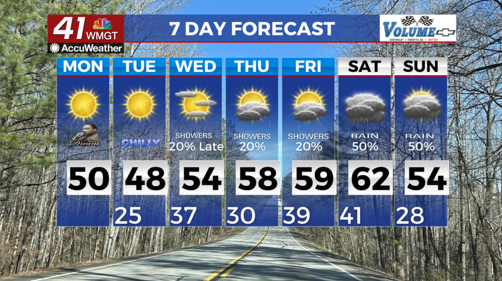
MACON, Georgia (41NBC/WMGT) – Morning commuters should exercise caution as patchy slick spots may exist. Ample sunshine prevails in the region today, allowing temperatures to warm 


 quickly this morning ending any black ice concerns before 11 AM. A secondary cold front pushes through the region this afternoon. Breezy winds behind the front will increase Cold Air Advection in northwest Georgia during the afternoon and limit highs to the 40s. The front should hold off long enough that locations in Middle Georgia that suffered snowfall Sunday will climb to near 50 degrees this afternoon. A small area of relative humidity below 25% could develop in northeast Georgia Monday afternoon. Fire weather concerns are not anticipated due to the recent precipitation and ambient fuel conditions. Dry conditions will prevail Tuesday and Wednesday. Westerly flow aloft at the base of a trough will promote a dry deep layer over north and Middle Georgia. Tuesday especially could pose a hazardous fire weather conditions, as relative humidity is forecast to bottom out in the teens to mid 20 percent during the afternoon. Depending on how effectively vegetation and finer fuels dry out this afternoon, a Fire Danger Statement may be issued on Tuesday. Wednesday could be borderline as well, as low level flow turns southwesterly and advects in Gulf moisture. A passing trough over the Ohio River Valley and associated cold front Wednesday night into Thursday support a slight chance of precipitation. Depending on the arrival time of the precipitation, a wintry mix is possible in northeast Georgia mountains late Wednesday night into Thursday morning. The cold front is not shaping up to be particularly strong, meaning that temperatures will not change much from Wednesday to Thursday. The next opportunity for precipitation will be Friday night through Saturday night.