Absolutely frigid temperatures expected overnight
MACON, Georgia (41NBC/WMGT) – Temperatures will plummet towards 20 degrees ahead of Friday morning.
This Evening
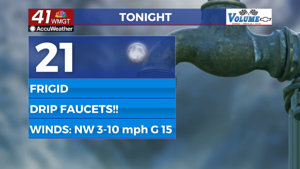
Skies have been sunny all day which has been nice considering the wind and cold. Once the sun sets things will really fell bitter as temperatures will be around last nights lows by midnight, continuing to drop towards the 20 degree mark by sunrise tomorrow. Middle Georgians need to bring their pets in and drip their faucets to avoid major plumbing issues. The wind will remain out of the northwest overnight but slow to 5-10 mph. The occasional gust will still reach to around 15 mph.
Tomorrow
Another sunny day is likely Friday with highs that will still be below average, however it will be much warmer than Thursday thanks to a shift in the winds. Temperatures should reach the low to mid 50s in the afternoon accompanied by southwest winds at 5-12 mph. Gusts should range from 15-20 mph.


Overnight cloud cover will fill in as conditions cool down, however lows will remain above freezing (likely upper 30s). Some showers will be possible during the sunrise hours on Saturday as another cold front will pass through the region over the first half of the weekend. Expect the wind to be rather breezy from the southwest throughout the night Friday into Saturday as well.
Saturday and Beyond
Conditions will be trying to dry out some following the frontal passage Saturday morning. Expect temperatures to reach the upper 50s and lower 60s Saturday afternoon, or around the average for this time of year. The wind will be working to shift from the southwest to the northwest throughout the day, ranging from 5-12 mph and gusts to around 20 mph.


Overnight Saturday and into Sunday is when winter weather could be possible, however the initial precipitation will likely be rain and once that moisture does start to arrive don’t be shocked if temperatures begin to climb. Additionally the ground will be above freezing in regards to temperature, so don’t expect any snowfall that may occur to start sticking immediately. Temperatures will rebound into the upper 30s and lower 40s Sunday afternoon, so if a shift from rain to mix/snow does happen, another shift back to rain also looks likely. Freezing over of some areas on the roads will be possible overnight Sunday into Monday as temperatures again drop to around 20 degrees to begin the new work week.

Follow Chief Meteorologist Aaron Lowery on Facebook (Aaron Lowery 41NBC) and X (@ALowWX) for weather updates throughout the day. Also, you can watch his forecasts Monday through Friday on 41NBC News at 4, 5, 5:30, 6, and 11 p.m.