


Above average temperatures return to begin the new week
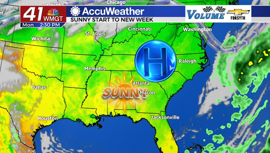
MACON, Georgia. (41NBC/WMGT) – Sunshine and warmer temperatures are returning to start the second week of November.
Today
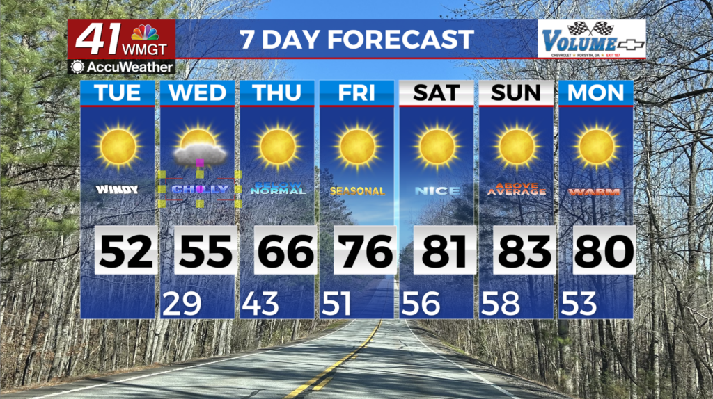
Following the wet and cloudy weather that ended last week and began the weekend, high pressure and sunshine returned on Sunday. Temperatures are climbing yet again this afternoon with highs expected to top off in the lower 70s. Cloud cover will be very scarce today with the potential for only a few small clouds to develop this afternoon. Wind will also be a lot calmer today than the end of last week, blowing again from the northeast but this time at only about 4-8 mph. Conditions overnight will remain clear with low temperatures falling into the upper 30s and lower 40s. Wind overnight will blow from the north-northwest at about 5 mph, keeping things clear, cool, and dry.
Tomorrow
Tuesday will be another sunny day around Middle GA however clouds do return to the forecast. During the late afternoon hours some high level cirrus clouds will move in overhead. Temperatures will also top off in the low to mid 70s, continuing the warming trend. Wind flow will shift from the northwest to the south-southwest ahead of lunchtime, allowing more moisture to move into the Georgia atmosphere. This is slowly setting the stage for another round of late week rain and storms. Overnight Tuesday the skies will see a good amount of cloud cover with the majority of it being cirrus clouds. Low temperatures will be in the mid to upper 40s thanks to increased moisture and cloud cover overnight.
Wednesday and Beyond
Wednesday will see a mix of sun and clouds as wind from the south-southeast brings more moisture to the GA atmosphere. Temperatures will maintain the mid 70s around Middle GA for the highs with most of the clouds filling in during the later hours of the day. Rain chances for Wednesday should hold off until after sundown at the earliest, however more than likely shower activity will not begin until Thursday morning. Overnight Wednesday expect plenty of cloud cover with lows only falling into the mid 50s ahead of Thursday morning.

Thursday (Veteran’s Day) is going to be the rainy day of the week, continuing yet again the trend of “sunny start, rainy finish” to our weeks this fall. Unfortunately with the system coming in on Thursday there will be a chance for severe weather. Shower activity is likely Thursday morning ahead of the cold front. The good news is the more showers and clouds there are early on Thursday, the lower the severe weather threat will be. With high temperatures in the mid 70s again Thursday afternoon and pockets of sunshine expected, there will be instability in place ahead of the cold front’s passing during the afternoon hours. As the cold front passes the formation of a squall line of storms will be possible. The primary threats with a squall line are strong straight-line winds, though a pop-up tornado will still be possible. Low temperatures heading into Friday morning will be in the mid to upper 50s.

Follow Meteorologist Aaron Lowery on Facebook (Aaron Lowery 41NBC) and Twitter (@ALowWX) for weather updates throughout the day. Also, you can watch his forecasts Monday through Friday on 41NBC News at Daybreak (6-7 a.m.) and 41Today (11 a.m).

Leave a Reply