Rain and storms increase Friday, ahead of weekend cool down
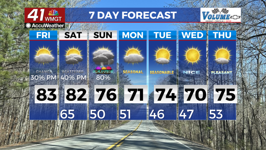
Our next weather system is moving into Middle Georgia Friday, bringing rain and storms. The weekend brings a big cool down and more rain

It has been another warm and humid day across Middle Georgia, resulting in a few pop up storms this evening.
Storms should start to dissipate after midnight, but clouds will hang around.
Friday brings our last warm day for a while, even with the partly to mostly cloudy skies.
After noon we will start to see rain and storms increasing in coverage across the area.
We are not expecting severe weather, but a few storms could contain heavy rain and frequent lightning.

Off and on showers will stick around overnight and into the day on Saturday.
Not only will it be rainy on Saturday, but we will also see a wedge front setting up.
This will be trapping cold air in our area and keeping it breezy for the weekend.
Highs on Saturday will be warming only into the mid and low 50s.

I know there are a lot of outdoor plans for Easter, but we may continue to see showers through Sunday afternoon.
We will see a bit of a warm up, but the wedge front won’t be moving out until around Tuesday.

Rain totals will be pretty widely ranged across Middle Georgia through the weekend.
Some areas could see up to 3″ of rain, while others might pick up less than 1″.
There is the potential for some more river flooding, so make sure you are staying weather aware.

We will finally start to see a bit of a temperature rebound for next week with highs warming back to the mid 70s.
Rain will once again return later next week, with a potential low pressure system emerging from the Gulf of Mexico.


