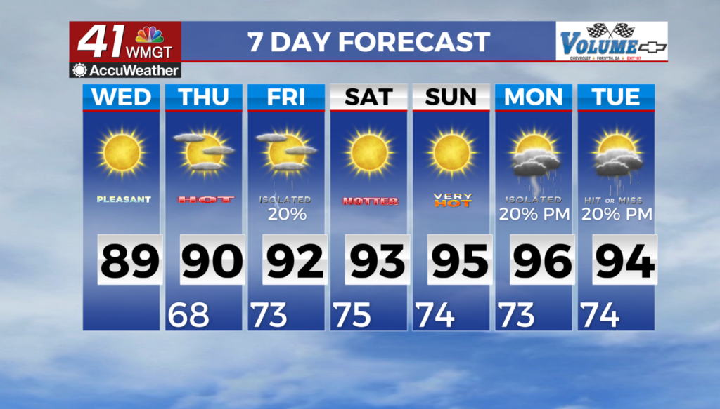

Cloudy and wet weekend on deck for Middle Georgia
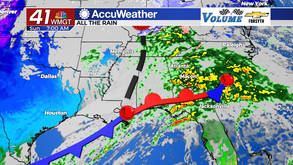
MACON, Georgia ( 41NBC/WMGT) – A low pressure system from the Gulf of Mexico will bring plenty of rain to Middle Georgia over the weekend.
Tonight
Cloud cover will continue to fill into Middle Georgia from the west during the overnight hours following a lovely Friday afternoon. A couple of rain showers will be possible for some of the southernmost counties tonight as well, but they likely wouldn’t occur until well after midnight. Overnight low temperatures will drop into the low to mid 40s around the region. Winds will blow from the northwest at 5-10 mph. Winds are expected to calm ahead of the sunrise on Saturday which could lead to some patchy fog.
Tomorrow
It will largely be an overcast day across Middle Georgia. For the first half of the afternoon it will likely be just clouds overhead, however an isolated shower cannot be ruled out. Winds throughout the day will generally blow out of the east at around 5 mph. Temperatures will peak in the upper 50s for most of the region. Shower activity will likely begin during the late afternoon hours, making its way into the southwestern counties first and working its way to the northeast.


Tomorrow night that rainfall will become a bit heavier and more widespread, especially after midnight. Temperatures will only drop into the upper 40s as a result of the more humid conditions. Wind speed will also pick up a bit as it shifts more towards the southeast. Expect the rainfall to become even heavier as the sunrise hours of Sunday approach.
Sunday
Sunday is the wet day of the weekend, especially early on. Throughout the morning hours heavy rain is expected across Middle Georgia. Winds will largely be blowing out of the south-southeast at this point at about 5-15 mph. This rain should taper off a bit around lunchtime, largely leaving cloudy skies overhead. A cold front will then begin to form somewhere either in the southeastern counties of Middle Georgia or just to the south of there. As this forms some thunderstorms will be possible.


Locations to the west of the cold front will see the wind shift to the northwest early. Those ahead of the cold front will likely see wind speeds push 20 mph from the southwest. High temperatures in the northwestern counties are expected to top off in the mid to upper 50s while the southeastern counties will be pushing into the upper 60s. As of now the farthest southeastern counties of Middle Georgia are under a Level 1 “Marginal” Risk for severe storms Sunday afternoon. The primary risks are strong wind gusts as the cold front takes form.


Rain should slow in the evening and likely stop by midnight across Middle Georgia. Cloud cover will clear out overnight as well with the west-northwesterly winds blowing in at 5-15 mph. Temperatures will bottom out in the low to mid 40s across the region.

Follow Meteorologist Aaron Lowery on Facebook (Aaron Lowery 41NBC) and Twitter (@ALowWX) for weather updates throughout the day. Also, you can watch his forecasts Monday through Friday on 41NBC News at Daybreak (5-7 a.m.) and 41Today (11 a.m).