Storm chances drop as heat wave continues
MACON, Georgia (41NBC/WMGT) – Relief from the heat will be harder to come by today as rain chances drop.
Today


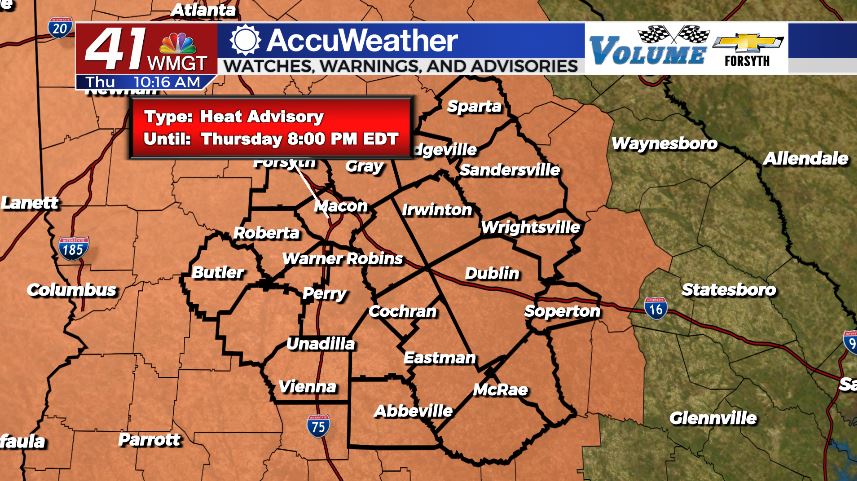
We will see plenty of sun throughout the day today in Middle Georgia. Cloud fields will begin to populate the sky during the lunchtime hours, however today’s rain chances are nowhere close to what yesterday’s were. Our highs today will luckily be cooler; topping off in the upper 90s instead of the lower 100s. And while the Excessive Heat Warning may not be in place for today, a Heat Advisory is in effect until 8:00 PM EDT. Heat indices will still push close to 108°-109° in the hottest spots later today, however, so we are not out of the woods with the heat by any means. There also won’t be much wind today; easterly flow at 4-9 mph will do little to help cool things down.

In terms of storm chances later today, our only opportunities will be a couple of small, isolated storms. Nothing widespread or organized is expected this afternoon, so 90% of Middle Georgia will not see rain. There is no risk for severe weather this afternoon or evening either.


The odds that one of the isolated storms this afternoon persist into tonight is slim but not zero. Once that clears out we will be left with partly cloudy skies until about midnight and then mostly clear from then on. Lows will mainly be in the lower 70s as the winds shift to the south-southeast at 4-8 mph.
Tomorrow


We will be heating up again tomorrow as temperatures will return the triple digits for about half of the region during the afternoon. Heat indices will obviously continue to be in the triple digits with a handful of spots seeing feels like temperatures of 110°+ tomorrow. Luckily our rain chances will escalate in the afternoon and evening as a weak cold front approaches the region. It will bring scattered storms through the evening and overnight hours, shifting the winds to a more westerly flow as it passes through.


Storms could persist into the overnight hours depending on how fast the cold front is moving, however activity should slow after midnight. We will begin to see drier air make its way in as the wind shifts towards the west-northwest at 5-10 mph. Lows will drop into the 70s overnight; how low they get will depend on the timing of the cold front and when the rain stops. The longer the rain persists, the warmer the lows will be.
The Weekend

Saturday will be a relatively pleasant day despite the weather models disagreement on potential high temperatures for the day. Given the fact that the wind will be rather breezy from the north-northwest (10-15 mph gusts 20+), the models calling for highs over 100 will likely be wrong. The north-northwest winds will be bringing in cooler and drier air to the region. Highs around Middle Georgia should mainly be in the mid to upper 90s. Cloud cover will be a bit reduced from the past couple of days as well, making for plenty of sun in the afternoon. Overnight we should see lows return to the upper 60s across the board.

Father’s Day will be the most pleasant day of the next 7 with highs in the low to mid 90s. Storm chances are negligible and cloud cover will likely be at its lowest for the week. Winds will still be somewhat breezy from the northeast at 7-12 mph, adding a cool breeze to help with the heat as well. Humidity will also be down as a result of the drier air that moved in Saturday. Lows will be in the low to mid 60s, bringing on the coolest night in about two weeks.

Follow Meteorologist Aaron Lowery on Facebook (Aaron Lowery 41NBC) and Twitter (@ALowWX) for weather updates throughout the day. Also, you can watch his forecasts Monday through Friday on 41NBC News at Daybreak (6-7 a.m.) and 41Today (11 a.m).