Strong storms to follow hot afternoon
MACON, Georgia (41NBC/WMGT) – Temperatures will peak over 100 degrees for much of Middle Georgia this afternoon and thunderstorms are likely this evening.
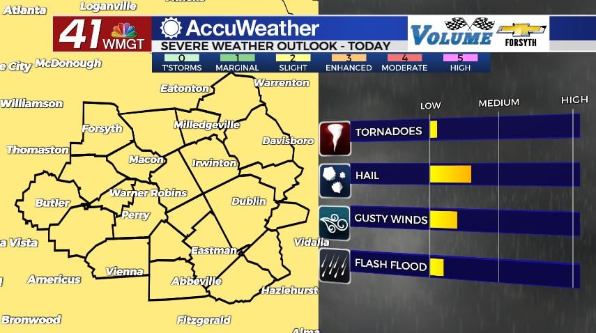
Today


It was a relatively pleasant morning to kick things off around Middle Georgia today. Heat indices and actual temperatures were identical this morning thanks to drier air that moved in yesterday evening and overnight. It will not stay that way, however. Excessive heat warnings are already in effect across the entire region and will remain in effect until 8:00 PM EDT. Heat indices will eclipse 105° with some spots getting over 110°. Actual highs today will be over 100° for the majority of the region. Wind will be rather calm from the east-northeast, coming in at around 5 mph.


Later this evening (5PM and later) we will see scattered storms fire up. The Storm Prediction Center (SPC) has issued a Level 2 “Slight” risk for all 0f Middle Georgia in relation to these storms. There won’t be any actual organization to these storms which basically nullifies any tornado threat. Small to medium sized hail, however, will most certainly be on the table due to strong vertical updrafts. Heavy downpours could bring some strong winds in the form of downbursts as well. These storms will persist into the overnight hours.


Storm activity will likely not slow down right as the sun sets, which is a bit different than normal for this time of year. However, we should begin to see the rain taper off a bit as we head towards midnight. Rain lasting beyond that will be rather light, and all storms will be gone before sunrise tomorrow. Due to the excess moisture heat indices overnight will remain above 80° for most of the region, however spots that see little rain may drop below. Actual lows will be in the mid 70s for most of the region.
Tomorrow


It will be another hot day as highs climb into the upper 90s around the region. A couple of spots may still get up over 100°. Wind will be rather calm from the east-southeast as it comes in at 5 mph. Cloud fields will develop in the afternoon, but overall skies should remain partly sunny. Storm chances will be very isolated, however the northeastern portion of the region could see slightly more organized storm activity than the rest. Storms should also hold off until the evening hours (much like today) as well.


Storm activity will persist during the early overnight hours, but should clear ahead of midnight. Skies after that should be clear as the wind comes in from the south-southeast around 5 mph. Lows will be in the low 70s, and heat indices should be as well.
Friday and Father’s Day Weekend

Friday will be another scorcher with 50+% of Middle Georgia seeing highs over 100°. Heat indices will again mainly hover between 105° and 110°. A few scattered showers and storms look to fire up during the afternoon and evening hours as a very weak “mini cold front” passes through, but they should not persist into the night. Lows will drop into the lower 70s.
Saturday will be the same as Friday in terms of temperatures, however the wind will be a bit more breezy as it comes in from the north-northwest at 7-12 mph. Gusts could reach upwards of 20 mph. This will finally allow for some drier (and slightly cooler) air to move into the region ahead of Father’s Day on Sunday. Overnight skies will be clear as lows drop into the upper 60s and lower 70s.
Father’s Day will be the coolest day of the next 7 as highs reach the low to mid 90s. Heat indices should stay below 100° due to the drier air brought in on Saturday. Storm chances will be negligible. Overnight lows will drop into the mid to upper 60s.

Follow Meteorologist Aaron Lowery on Facebook (Aaron Lowery 41NBC) and Twitter (@ALowWX) for weather updates throughout the day. Also, you can watch his forecasts Monday through Friday on 41NBC News at Daybreak (6-7 a.m.) and 41Today (11 a.m).