Plenty of showers expected throughout the day Friday; severe threat still in place for early Saturday morning
MACON, Georgia (41NBC/WMGT) – Messy weather will hang around the southern half of the Peach State Friday afternoon, and a cold front overnight will bring strong storms to Middle Georgia.
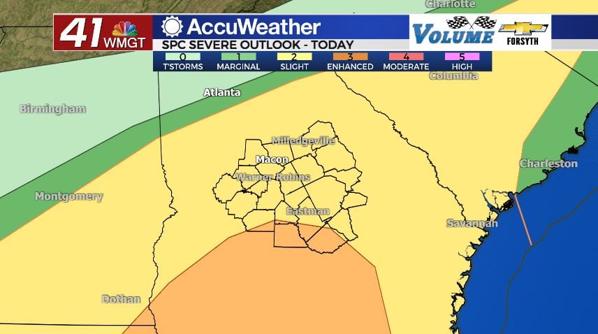
Today


The mild, humid, and wet trend continued for another morning around Middle Georgia, and several spots began the day with some fog. It will overall be a cool day today as highs only reach the low to mid 60s. A couple of southern counties could crack into the upper 60s this afternoon. The wind will be rather gentle from the east-northeast at 5-10 mph. Scattered showers are likely around the region during the day with some heavier rainfall more likely in the afternoon for the southern counties. The cooler and cloudier it stays today, the lower the severe threat will be tonight. If we see more widespread rain around the region late, especially the southern counties, that should further reduce the risk.


Tonight’s severe weather threat is a Level 2 “Slight” risk for most of the region with Wilcox, Telfair, and southern Dodge, Pulaski, and Dooly counties being in the Level 3 “Enhanced” risk zone. The primary risks for tonight remain heavy rain and strong straight-line wind gusts. These are most likely to occur as the cold front rolls through, likely after 3 am Saturday morning. The tornado threat will come from individual supercell storms that fire up in front of the cold front. The potential for these storms to form will continue to drop should shower and rain activity around the region continue into the evening hours. It is still highly suggested to have a weather radio nearby as well as a way to get warning information overnight. Setting an alarm at 3 am might be really annoying, but it could also be lifesaving if the overnight tornado threat persists.


The rain should clear out shortly after the sunrise Saturday morning. Low temperatures will bottom out in the upper 30s and lower 40s. Winds will shift from the south-southwest at 15-25 mph ahead of the cold front to the northwest at 20-30 mph once it passes.
Tomorrow


Following the cold front’s passing early in the morning, the skies over Middle Georgia should clear rather quickly. The sky conditions will remain clear the rest of the day, but there won’t be much else pleasant about the weather. High temperatures around the region will be in the low to mid 40s with a couple of upper 40s likely in the southern counties. The temperatures outside will likely never feel that warm, however. Northwest winds at 20-30 mph will howl all day, and gusts will likely reach speeds of 40-45 mph. A wind advisory is already in effect for all of Middle Georgia, and it isn’t set to expire until 7:00 PM tomorrow night.

Overnight conditions will be extremely cold. Do not forget to drip your faucets to prevent pipe bursts, and if you have pets or plants outside please make sure to bring them in. Lows will fall into the the lower 20s rolling into Sunday morning, with even the warmest spots even dropping to about 25 degrees.
Sunday
Sunday will be the most pleasant day of the weekend as sunny skies hang around and temperatures actually warm back up a bit. It will also be the first day of Daylight Savings, so don’t forget to set your clocks forward an hour! Highs will be in the mid to upper 50s around the region as the wind shifts back to the southwest at around 5 mph. Clear conditions will stick around all day.
Overnight the skies will still be clear as lows fall into sub-freezing conditions again, only this time it should be the lower 30s and maybe a couple of upper 20s. Your faucets should be fine left alone, but pets and plants should still be brought in.
Next Week
The sunny conditions will hang around for the first half of Monday, but the clouds will return in the evening with a new rain train likely to begin Tuesday evening. We will again have the potential for widespread rain all of Tuesday night and into Wednesday, and it looks as though there could be another system next Friday or Saturday. Temperatures should be a bit warmer than this past week, but we will likely see just as many clouds.

Follow Meteorologist Aaron Lowery on Facebook (Aaron Lowery 41NBC) and Twitter (@ALowWX) for weather updates throughout the day. Also, you can watch his forecasts Monday through Friday on 41NBC News at Daybreak (6-7 a.m.) and 41Today (11 a.m).