Another dry and breezy day before cloudy skies take over
MACON, Georgia (41NBC/WMGT) – A strong surface high pressure centered off the Northeast coast will continue to nose southward into the area, with high pressure setting up over the 


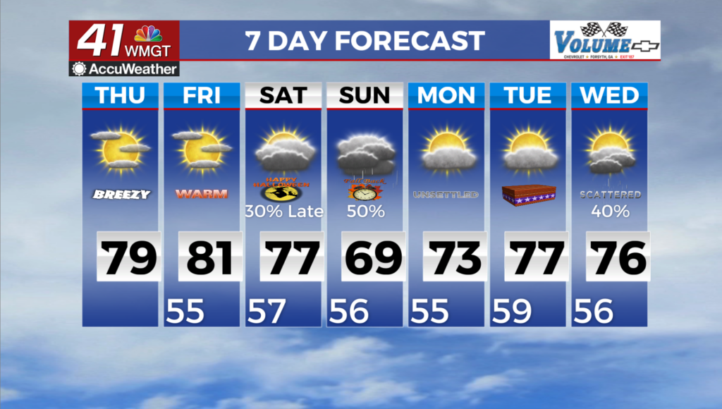
Tennessee Valley region for Thursday. Combined with a weak low off the coast of Florida, this will lock in a northeast to east flow and work to funnel a more moist low level profile over the region. This moisture profile will increase the cloud cover for this morning before lifting in the afternoon. Otherwise, a more mid to upper level clouds will stream in on Thursday night as cirrus clouds spill over the ridge. The primary impacts of this will be a continuation of the dry and rain-free pattern, with a few more clouds around. Temperatures will run a few degrees above normal today, with highs in the low to upper 70s to near 80 and lows in the lower to upper 50s. Northeast winds around 5 to 10 mph will continue with occasional low end gusts this afternoon. Temperatures 

during the daytime will climb into the low to mid 70s across most of the coverage area before we see some low 80s as we go into the weekend as the winds swing around to the south. High pressure begins to break down with the approach of a trough from the west and we’ll see the chances of showers and possibly a thunderstorm start to increase late on Saturday evening before sweeping through on Sunday. While the threat of severe weather is marginal, the GFS model shows a decent amount of rain on Sunday with amounts ranging from about 1.5 inches to 2.5 inches. On the other hand, the European model keeps rainfall totals at less than half an inch, coming in with a significantly drier solution. No matter how it plays out, current drought conditions should minimize the overall flood threat. Some localized flash flooding will be possible if the GFS gets it right with training storms in the metro area. The system clears out late Sunday, giving us a few more days of clear Fall weather. Another round of rain and possible a thunderstorm will creep back into the forecast towards the middle of next work week.