
Summer’s last gasp before cooler temps arrive midweek
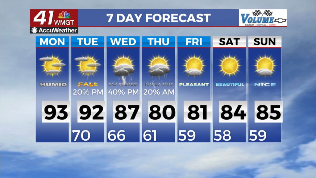
MACON, Georgia (41NBC/WMGT) – Today we will see a surface high slide into the Midwest and the Northeast in the upper levels as an exiting trough moves towards the Atlantic. Along the 


southern edge of a gradient setting up from that forementioned high. That will be a weak impulse riding through the Ozarks to the east. This will act as an additional source of lift along and ahead of the frontal boundary pushing to the south and stalling. The best chances of rain and thunderstorms appear to be focused in Northern Georgia, trailing off into Middle Georgia. Shear remains weak, however daytime heating and high moisture levels in the atmosphere combined with a bit of cooling aloft and a weak forcing mechanism may all combine to allow for a few severe storms, capable of damaging wind gusts. Our days of 90 degree high temperatures may be numbered, but this will be yet another we will all get to suffer through together. The long term forecast begins on Tuesday, which is the first day of astronomical Fall! While conditions will be far from Autumnal, we will get a break from the heat from Wednesday forward, as temperatures drop to around 
normal for this time of year. The Storm Prediction Center has all of North Georgia and parts of Middle Georgia under a Marginal Risk (Level 1 out 5) for severe storms on Tuesday as a shortwave trough traverses the Tennessee River Valley. Ample instability should blossom ahead of and along the line, sparking convection that may develop upscale into a stronger storm. As a result, the peak in thunderstorm coverage across parts of North and Middle Georgia may end up being early Tuesday evening into the overnight hours. Damaging wind gusts would be the primary hazard, with small hail, frequent lightning, and heavy rainfall as secondary hazards. A strong area of high pressure will anchor itself over eastern Canada from midweek through the weekend, leading to cold air damming (the wedge) here across the area. While the associated airmass will be drier overall, enough moisture will remain in place initially to support isolated to scattered showers and storms on Wednesday and Thursday. Where thunderstorm coverage is maximized on Wednesday may depend on where the outflow boundary from the convection on Tuesday evening ends up. Even drier air is scheduled to move in on Friday and Saturday as high pressure increases and northerly/northeasterly low level flow prevails, so rain chances those days are essentially zero areawide.