Stormy week ahead as temps are cooler
MACON, Georgia (41NBC/WMGT) – The synoptic unsettled pattern remains relatively unchanged with a disturbance stout near a ridge pivoting from the Central Rockies into the Northern Plains. 


Farther downstream, east of the Mississippi River, a weak trough and associated upper low continues to slowly drop from the Ohio Valley across the Southern Appalachians today. At the same time, high pressure at the surface is settling over New England will drop a weak back door front south across the Carolinas towards Georgia, through most of the day on Monday. These features interacting with a moist airmass will foster the development of numerous to widespread showers and thunderstorms this afternoon. Some of these robust cores will be capable of producing locally damaging microbursts, especially with any convective clusters that can grow along cold pools. The presence of synoptic forcing will allow convection to linger and redevelop beyond the traditional 


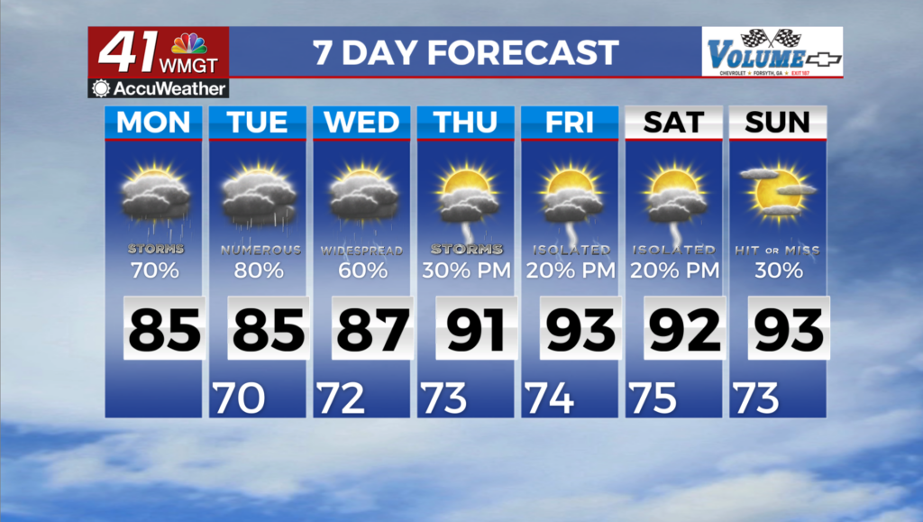
summer pulse window. Some models show convection overnight, especially across the north Georgia mountains where at least some component of the flow will be aligned favorable for orographic (lifting) enhancement. For today, the weak closed upper low settles more directly over the area and will likely allow for another round of numerous to widespread showers and thunderstorms. Copious amounts of cloud cover will result in temperatures a good bit below the norm with highs in the low to mid 80s, which will have implications on the available instability. Despite sufficient coverage of storms, this will generally limit the severe potential. Although with any summer storms, an isolated wet microburst or two cannot be ruled out. Isolated flash flooding will also have to watched as slow moving storm clusters and boundary interactions could yield pockets of locally higher rainfall. Tuesday picks up with more rain expected across the region. The cut off low delivering our current rounds of rain will begin to slowly meander to the west underneath a breaking upper level ridge over northern portions of the U.S. For Wednesday, this means that shower possibilities will return to a more typical summer pattern with late afternoon and evening storms driven by daytime heating. Temperatures are forecast to slowly rise through the week. With rain and cloud cover sticking around, temps will be 5 to 10 degrees below average Tuesday with highs in the 80s.