Another round of showers later for Middle Georgia
MACON, Georgia (41NBC/WMGT) – We are expecting low clouds and/or fog to scatter and lift by mid-morning as southwest flow increases. Temperatures may be a tad bit warmer than yesterday 


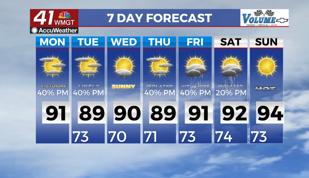
with forecast highs in the upper 80s to low 90s. Heat indices will follow suit with values in the 90s to low 100s (Middle Georgia). The main story for today will be the potential for strong to severe thunderstorms to push through during the evening hours in association with an approaching cold front. Isolated to scattered showers may begin developing out ahead of this system by early afternoon across parts of North Georgia. The latest guidance is consistent on late afternoon to evening timeframe for any severe potential. This is in tandem with slightly more favorable support 


and frontal forcing despite the loss of daytime heating. We can expect a Slight Risk (Level 2 out of 5) for North Georgia to highlight this potential. Damaging wind gusts will be the primary concern however, enhanced shear may support an isolated spin up tornado threat for far northwest Georgia. Localized flash flooding will also be a threat if storms repeatedly move over the same areas. Overall, we anticipate the line to begin to fall apart as it pushes through North Georgia into Middle Georgia as it becomes further displaced from upper level support. Shortwave troughing will exit to the east on Tuesday, with a trailing cold front expected to push slowly southward into central and southern Georgia through the day. Chances for showers and storms will progress southward with the front, with mainly dry conditions expected behind the front across north Georgia by the afternoon. Northwest flow will persist behind the front Wednesday, keeping deeper moisture mainly to the south and lowering our shower/storm chances to less than 20 percent for much of the area. Rain chances will then increase once again Thursday afternoon as southwest winds transport Gulf moisture back northward. Some models are suggesting subtropical ridging may then build over the area Friday and into the weekend and help suppress storm chances somewhat, but at least isolated showers and storms appear possible into next weekend given the moist and unstable airmass. Temperatures will remain in the mid to upper 80s north and west and upper 80s to low 90s south and east.