Father’s Day weekend will see more storm opportunities
MACON, Georgia (41NBC/WMGT) – A lingering stationary front will bring more rain Saturday before temperatures warm up for Father’s Day Sunday.
This Evening


Rain should be mostly done for the day across Middle Georgia following a wet Thursday. Rain totals from the event pushed 6 inches in the wettest spots with several in the southern half of the region receiving at least 3. A Flood Watch remains in effect until 2 AM later tonight. Overnight will be partly cloudy with temperatures dropping into the lower 70s across the region. The wind will be a lot calmer than last night as it flows from the west-northwest around 5 mph.
Tomorrow


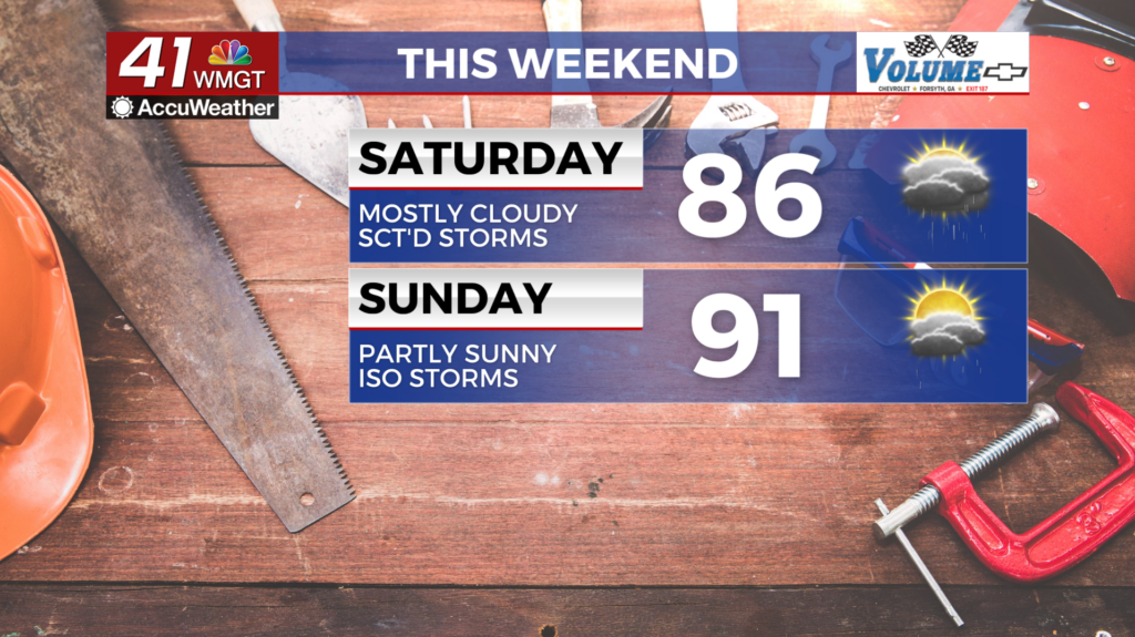
The cloud cover will return early Saturday with some rain possible leading into the start of the day. The peak storm chances look to be in the middle of the day with some clearing expected during the evening. High temperatures will likely only reach into the mid 80s for most of the region thanks to rain earlier in the day. The wind will flow from the northwest around 5 mph. Severe activity is not expected with the storms tomorrow however mature storms may bring small hail or a couple of strong wind gusts.


Overnight will be partly cloudy and muggy with temperatures again dropping into the lower 70s. The wind will be light out of the west around 5 mph. Fog will be possible (and could be dense) heading into Sunday morning.
Father’s Day and Beyond


Sunday will be a sunnier and warmer day as temperatures should reach the 90s across the majority of the region. Heat indexes will push triple digits in the hottest locations thanks to all the moisture in the area from this week. A few isolated storms or showers will be possible over the latter half of the day. The wind will flow from the west-southwest at 5-12 mph with the occasional gust reaching around 17 mph.

Partly cloudy skies and isolated storm odds are likely each day next week with some days potentially seeing more widespread activity. Temperatures will be around the average in the afternoons and the lows will remain slightly above average in the lower 70s.

Follow Chief Meteorologist Aaron Lowery on Facebook (Aaron Lowery 41NBC) and X (@ALowWX) for weather updates throughout the day. Also, you can watch his forecasts Monday through Friday on 41NBC News at 4, 5, 5:30, 6, and 11 p.m.