Off and on showers and storms expected tonight and tomorrow
MACON, Georgia (41NBC/WMGT) – Rain creeping north from South Georgia will stick around Middle Georgia tonight and tomorrow as a stationary front drapes across the Peach State.
This Evening
A mostly cloudy afternoon will stay that way heading into tonight with cloud cover thickening as rain odds climb. Scattered storms are pushing northward from South Georgia into Middle Georgia heading into suppertime. Expect the rain to continue off and on through the night. While storms remain possible overnight the amount of lightning and thunder should be a good bit less than while the sun is out. Temperatures will valley in the upper 60s for most of the region as the wind flows from the west around 5 mph.
Tomorrow
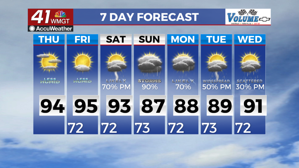
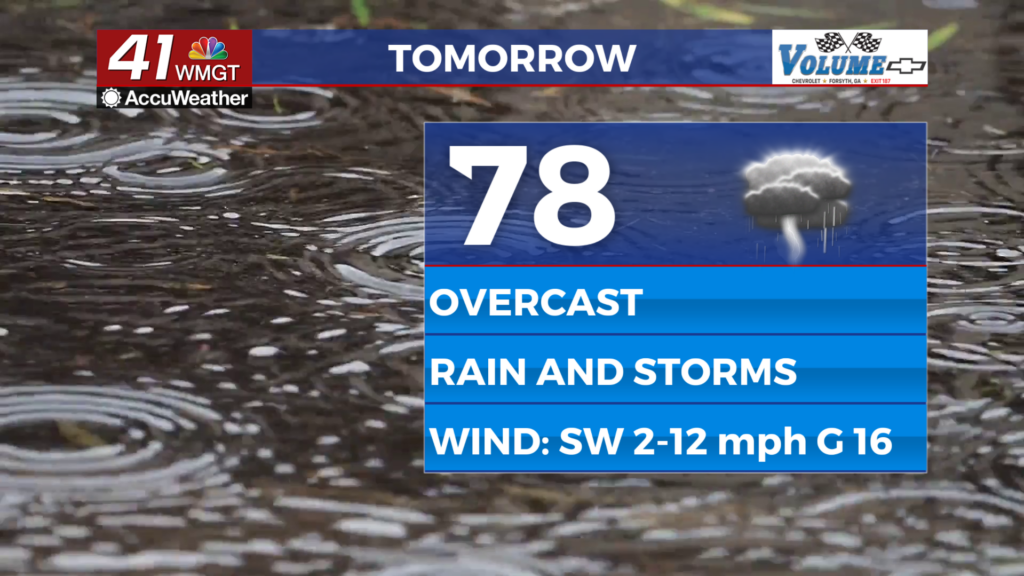
Middle Georgians should prepare their rain gear for Tuesday as it will be the coolest (although it will not feel that way) day of the week with several showers and storms likely all day long. The skies will be overcast to go with them. Temperatures will peak in the mid to upper 70s; however with dew points in the upper 60s and lower 70s it will be very sticky outside despite the below average temperatures. The wind will flow from the southwest at 5-12 mph with gusts reaching 15-17 mph.


Overnight some rain will continue along with the possibility for a couple of thunderstorms. Temperatures will again mostly drop into the upper 60s heading into the following morning. The wind will continue from the southwest at 5-12 mph.
Wednesday and Beyond
Storm chances will be scattered again on Wednesday during the afternoon and evening hours, however more sunshine during the day will allow temperatures to climb back into the mid to upper 80s for their afternoon peaks. Storm odds will remain elevated as another front moves into the area late this week. To go along with that a tropical disturbance in the Gulf is likely to move inland along the Gulf Coast later this week. Combined with the aforementioned front the rain odds will be extremely high heading into the weekend and much of the Southeastern US may end up dealing with flooding threats. Should the area in the Gulf organize enough before moving inland it would be called Arthur which is the first name of the 2026 Atlantic Hurricane Season.

Follow Chief Meteorologist Aaron Lowery on Facebook (Aaron Lowery 41NBC) and X (@ALowWX) for weather updates throughout the day. Also, you can watch his forecasts Monday through Friday on 41NBC News at 4, 5, 5:30, 6, and 11 p.m.