
Isolated storms possible, then a brief cooldown
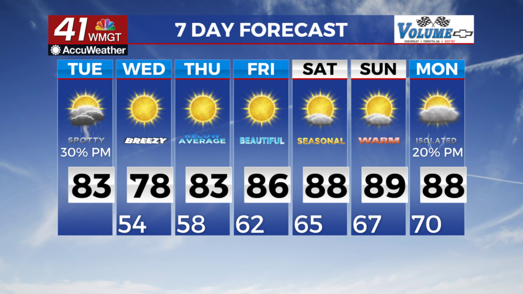
MACON, Georgia (41NBC/WMGT) – The wedge is still in place and is expected to temporarily retreat today as winds turn to the northwest this afternoon. During that time, expect a few patches 


of blue skies with scattered cloud cover today which should allow temperatures to climb into the low 80s across the area. Looking towards the late afternoon into the evening, a disturbance looks to approach North Georgia before pushing southward. Expecting this wave to push more into Alabama due to better elements in this area in addition to the influence of the wedge that is still in the Carolinas. There is a low end chance that if this wave is able to hold together, we could see an area of showers and isolated thunderstorms push all the way to the Macon area. More than likely 


this system will fizzle out as it gets closer to the metro as it looses most of the forcing and better environmental conditions. Temperatures will also be cool with highs in the mid to upper 70s. Rain chances will be confined more towards Middle Georgia but the storm mode seems to be more organized in nature. North Georgia looks to start the drying trend a bit early on Tuesday with rain chances staying mostly low. From Wednesday through the end of the work week, we can expect mostly dry weather across North and Middle Georgia. High pressure extends southward from the Great Lakes region and ridging aloft will slowly slide east encompassing much of the Eastern U.S. by Thursday. Temperatures will be quite comfortable during this time, even chilly especially Thursday morning. Highs will be in the 70s areawide on Wednesday with dewpoints in the 50s. This will be a much welcome change from the warm and humid conditions we have been experiencing. Wednesday night into Thursday morning temperatures will be in the 50s areawide. As ridging aloft starts to dampen and the high gradually shifts east, expect temperatures to gradually trend warmer as we head into the weekend.