
Rain chances remain in the forecast through Tuesday
MACON, Georgia (41NBC/WMGT) – North Georgia is still under the influence of the Wedge/Ridge that’s centered over the Mid-Atlantic states nosing down the eastern seaboard and into 


North Georgia. This wedge is keeping moist easterly flow over the state with low clouds and steady east winds. By Monday, the wedge looses its grip on North Georgia as the high pressure ridge gets pushed off shore by an incoming frontal boundary from the northwest. This will turn winds more northwesterly and scatter the low ceilings out through mid-morning to early afternoon. Currently there is a Marginal Risk for severe storms from the Storm Prediction Center due to a few waves pushing southeast into the area in the northwesterly flow. There does remain a low chance that a cluster of storms could dive into Northwest Georgia Monday afternoon and evening that could lead to a low end damaging wind concern especially in areas that have looser soils 


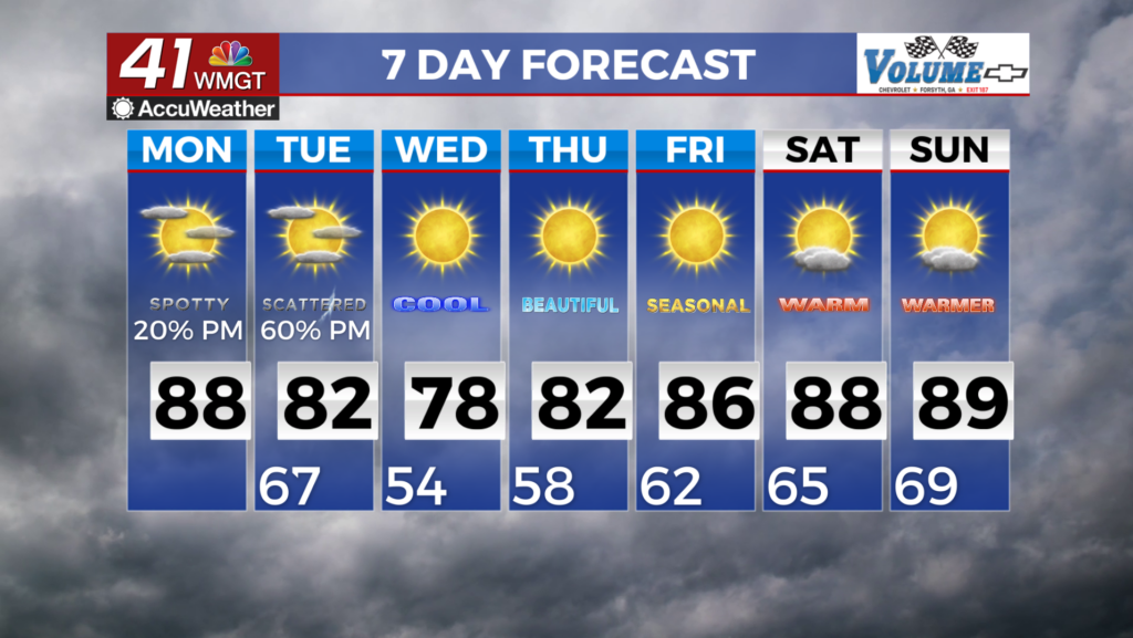
due to the rainfall this past week. Other parts of the area may see isolated storms throughout the afternoon and evening but overall a drier pattern shift is beginning to take place as we move into the extended period. Low temperatures will mainly be in the 60s tonight with highs in the 80s. As we start Tuesday, another back door front pushes into the area from the north eventually followed by an upper trough. Exactly where and how far south the frontal boundary ends up is still in question as well as the interactions with a departing low off the Atlantic. The location of the 


front will ultimately determine the places that are likely to see showers and thunderstorms on Tuesday. Latest ensemble models continue to reflect these placement uncertainties. The highest chances for rain are portions of south-Middle Georgia and at higher elevations. The upper ridging draped southwest to northeast up the Mississippi Valley Region and surface high pressure extending southward from the Great Lakes to the Southeast looks to remain in place from Wednesday through at least the end of the week. This will promote drier and more comfortable temperatures at least for Wednesday into Thursday, to start off the month of June. Temperatures are forecast to be in the 70s areawide with dewpoints in the 50s on Wednesday. Thursday morning lows are forecast to be in the 50s areawide. As upper ridging and the surface high slides eastward through the week, expect temperatures to gradually trend upward each day.

